
An “Air Age” Map of the World, 1945

The aeronautical correspondent of The Times, London, calls attention to the fact that the British Overseas Airways Corporation has issued a new type of world map, designed to “re-teach” geography in a form more suited to the coming “Air Age”.
It points out that because the earth is a sphere and maps of the world are flat, every type of map gives a distorted picture. On a Mercator projection, now commonly used for world maps, the distortion increases according to the distance from the equator. For instance, Greenland is shown as being about the same size as South America, whereas its area is only about one tenth of that continent. Distances between widely separated places also become exaggerated, particularly in high altitudes.
At present, maps drawn on the Mercator projection are used for both sea and air navigation, but whereas ships must follow tracks which may involve long detours to avoid land masses, the aeroplane can follow the shortest route –a straight line over the Earth’s surface. Now that airliners are being designed to fly non-stop over long distances, a new type of map is needed which will enable the intending passenger to read accurately the distances he has to cover.
To indicate the distance from London of places all over the world which will be served by British air services, the British Overseas Air Corporation has prepared what is known as an azimuthal equidistant map centered in London. Straight lines drawn from London to any other point on the earth’s surface will show accurately the distances separating them, though no necessarily the route which will be followed.
On the azimuthal equidistant map a straight line indicates a Great Circle course, but such a direct route is not likely followed by air services in the years immediately after the war unless it happens to serve big centers of population or important business areas. Such routes, in general, will not be used for air services until there have been further development in the speed, range and economies of long distance flying.
The British Overseas Airways Corporation object in producing an “Air Age” map now is to encourage the teaching of this new conception of geography in schools, so that boys and girls will grow up air minded.
*****
Order 1945 Flat Earth Air Age Map of the World Azimuthal Equidistant on Ebay
This map is of high quality I got on Ebay and shows the actual miles distance of world’s major countries and cities from point to point.
Gall/Peters Projection Overlay of both maps Mercator Projection


World Maps Are Wrong
The Mercator Projection Map is the most common map used in schools, textbooks and relied upon by millions of people every single day. The true scale of land masses relative in size and shape to one another are all wrong and gives us a very distorted representation of the world. The traditional “Mercator Projection Map” has a cultural and ethnic bias because of the relative and distorted sizes of the land masses creating a Eurocentric bias favoring Western civilization and greatly minimizing the size of South America and Africa. The Mercator Map represents Greenland and Africa as being roughly the same size however in reality, Africa is 4 times as large as Greenland. Africa is in fact 30.221 x 1000 sq. Km.
The American Cartographer Association (ACA) calls for an accurate flat, round Earth Map. The ACA, now Cartography and Geographic Information Society, has produced a series of booklets (including Which Map Is Best) designed to educate the public about map projections and distortion in maps. In 1989 and 1990, after some internal debate, seven North American geographic organizations adopted the following resolution, which rejected all rectangular world maps, a category that includes both the Mercator and the Gall–Peters projections:
WHEREAS, the earth is round with a coordinate system composed entirely of circles, and WHEREAS, flat world maps are more useful than globe maps, but flattening the globe surface necessarily greatly changes the appearance of Earth’s features and coordinate systems, WHEREAS, world maps have a powerful and lasting effect on people’s impressions of the shapes and sizes of lands and seas, their arrangement, and the nature of the coordinate system, WHEREAS, frequently seeing a greatly distorted map tends to make it “look right.”
THEREFORE, we strongly urge book and map publishers, the media and government agencies to cease using rectangular world maps for general purposes or artistic displays. Such maps promote serious, erroneous conceptions by severely distorting large sections of the world, by showing the round Earth as having straight edges and sharp corners, by representing most distances and direct routes incorrectly, and by portraying the circular coordinate system as a squared grid. The most widely displayed rectangular world map is the Mercator (in fact a navigational diagram devised for nautical charts), but other rectangular world maps proposed as replacements for the Mercator also display a greatly distorted image of the spherical Earth.

Man U really do got a lot of spare time to shill around in truther’s blogs I can’t believe you still believe in this spinning ball !!
LikeLike
Trying to calculate distance from lisbon to paris on azmuthel equidistant map can you please tell me the distancw in miles. Or direct me to tools to answer the question. Thx
LikeLike
Trying to calculate the distance from lisbon to paris on
Azmuthel Equidistant Map in miles Can you please help?
Thank you
LikeLiked by 1 person
It is amazing that in the 21st century there are still slaves of the flat Earth cult invented in the early 19th century by a religious nut.
LikeLiked by 1 person
If the premise that the world is, indeed, flat, then creating an accurate map should not be all that difficult. True, an accurate map which is necessarily 2D is nearly impossible to represent a sphere. It is this inability to find an accurate map that makes me question the FE concept despite seeing many logical conclusions with regards to cosmology, local observations, physics anomalies, etc.
LikeLike
The distance when travelling 10˚ due east or west parallel to the equator.
At 60˚N or S the distance is 300 nm or 555.8 km. Personal experience.
At 30˚N or S the distance is 520 nm or 962.3 km. Personal experience.
On the Equator the distance is 600 nm or 1111.2 km. Personal experience.
For correcting sextant altitudes for the Earth’s curvature the formulae are;
Dip = 0.97 x Square Root (Ht of Eye in feet). Personal experience.
Dip = 1.76 x Square Root (Ht of Eye in metres). Personal experience.
Also magnetic compasses only function because of the earth’s magnetic field, which only exists as it is because the earth is spherical. There is no such thing as a mono-pole magnet in nature. Only people who have actually worked with them or studied their development know this. I have done both. Not a single FE cultist has done either. Not a single one. Never. Not a one. Personal experience.
Gyrocompasses only work because the Earth is slowly rotating and gravity is a fact. Only people who have actually worked with them or studied their development know this. I have done both. Not a single FE cultist has done either. Not a single one. Never. Not a one. Personal experience.
LikeLike
Tear apart a microwave oven and you’ll find ring magnets. These are also used in various types of high power RADAR systems. A flat circular magnet with one magnetic pole in the center and the other at the outer edge exists.
I was a gyrocompass tech in the Navy. I helped install, operate and test the very first ring laser gyro navigation system on a submarine. Gravity was never in the equation. No circuits, cards, algorithm or special anything accounts for gravity. In all my years driving subs we never accounted for gravity for any reason.
Guess who else never does?
Aircraft Pilots. Go and ask one.
LikeLike
Yes, there are manufactured ring magnets which are neither monopole nor spherical and do not exist in nature. They are basically bar magnets arranged to form circle, i.e. ring magnets have zero to do with Earth’s magnetic field and prove my point.
I was obviously referring to mechanical gyrocompasses not ring laser gyrocompasses which depend upon Earth’s rotation and the Sagnac Effect rather than gravity and Earth’s rotation/
“In all my years driving subs we never accounted for gravity for any reason.” Yes you did but you don’t know enough to realise it.
“Guess who else never does?
Aircraft Pilots. Go and ask one.” Yes they do. I am a professional navigator and have been since 1960. I am a Master Mariner FG.
You weren’t a driver you were a techie with very limited knowledge, as your post proved.
LikeLike
VERENDUN…The Earth travels slowly you say!, We are told (personal experience, school bullshit) that the world is, 24,901 miles circumference at the equator, so it has to turn at a speed of 1,037m.p.h. for midday high noon Sun, to be at midday the next day in a 24 hour period, that means the earth turns at 287m.p.h. faster than the speed of sound, which they also tell us is around 750m.p.h. at sea level,(did you see that SEA LEVEL, not sea curve), so its not slowly, fact, mr. experience, how does an aeroplane flying from London England land on an north south oriented runway in Nairobi Kenya on the equator on an Earth spinning so fast, how does the plane make up for the sideways movement of the Earth, I suppose its the magic of gravity.. A person in Australia has to be held on to this world by gravity stronger than someone in Scotland U.K. I weighed myself in Edinburgh Scotland before flying to New zealand, and I brought the same bathroom scales with me, when I arrived in Newzealand I weighted myself, I was still 87.5 kgs, so your gravity bullshit doesn’t work to help you out there either..Stop defending B.S. and actually do some fukin research instead of trying to defend rubbish that was not even explained to you at School, you just make excuses for it. Fact, Mr. Experience.
LikeLike
Slow, yes, slowly rotating at (7.2921150 ± 0.0000001) ×10−5 radians per second. or 1.15 x 10⁻⁵ rps or 0.000696 rpm. The surface movement at the equator, and only at the equator can be considered to be moving at 1,000 mph. The earth rotates slowly, very, very slowly, at half the rate of the hour hand on a clock.
“(did you see that SEA LEVEL, not sea curve): Indeed I did because sea level is a term referring to altitude, i.e, height with reference to the z axis, as you would know if you had any experience of the sea and things nautical.
“nce, how does an aeroplane flying from” The plane is moving in the atmpsap0hrere which is also moving with Earth due to billions of years of friction, amongst other things.
” I suppose its the magic of gravity” I suppose to the ill informed who believe in gods and magic that could be the case, but not to well adjusted people.
“A person in Australia has to be held on to this world by gravity stronger than someone in Scotland ” Why? Fg=G.m1.m2/r^2.
“actually do some fukin research” I note you missed : I am a professional navigator and have been since 1960. I am a Master Mariner FG.
When you were in Kiwi did you watch Alpha Ursae Minoris, did you ascertain its bearing and altitude? Do you even know how to calculate its true bearing?
Why is it that when you watch a ship sailing away from you the hull is the first thing to go below the horizon, then the superstructure and finally the funnel and upperworks?
horizontal?
Why is it that it is only possible to navigate accurately over long distances using spherical trigonometry?
Why is it that traditional gyro compasses work perfectly in low latitudes but became unreliable in high latitudes?
LikeLike
[…] Azimuthal Equidistant “Air Map” of 1945 proves Flat Earth […]
LikeLike
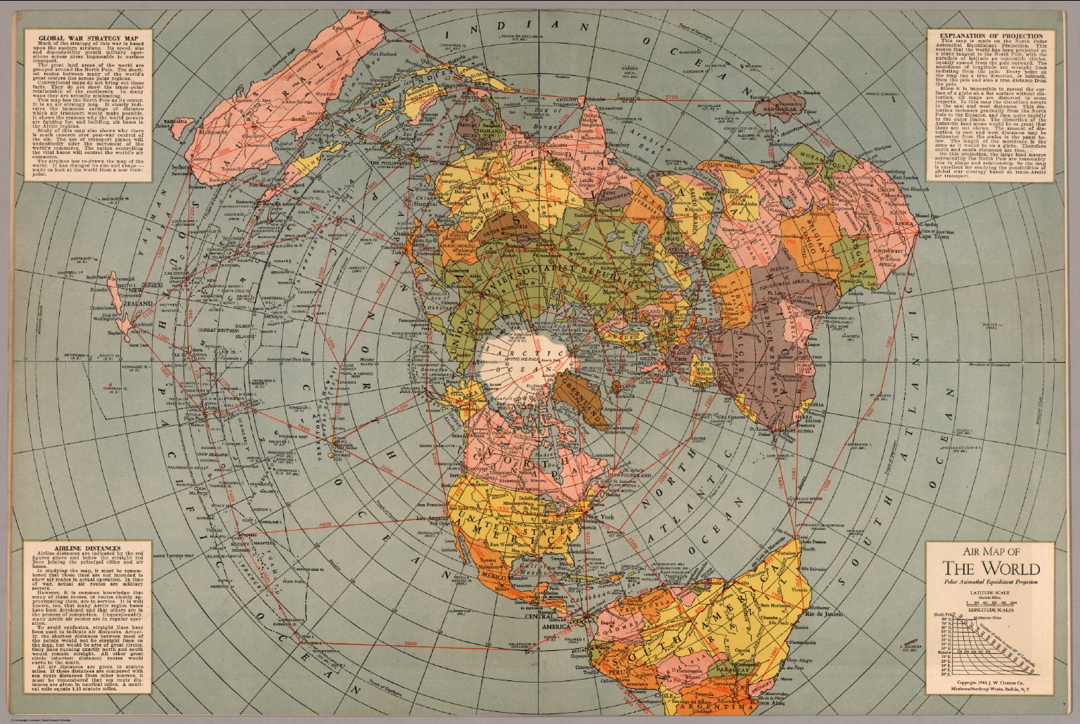
No it doesn’t. It clearly states “This map is made on the North Polar Azimuthal Equidistant Projection. This means that the world has been projected on ta plane tangent to the North Pole, with the parallels of latitude as concentric circles, equally spaced from the pole outward. The meridians of longitude ar straight lines radiating from the pole. Every point on the map has a true direction, or azimuth, from the pole and also a true distance from the pole.
Since it is impossible to spread the surface of a globe on a flat surface without distortion, all maps are distorted in some respects. In this map the distortion occurs in the east and west distances. This distortion increases gradually from the North Pole to the Equator, and then quite rapidly to the outer limits. The distortion of the Antarctic land areas would be so great that these are not shown. The amount of distortion in east and west distances may be estimated from the scales in the panel below. The length of the meridians is the same as it would be on a globe. Therefore north and south distances are true.
On this projection, the large land masses surrounding the North Pole are reasonably true in shape and relationship. So the map is excellent for studying the possibilities of global war strategy based on trans-Arctic air transport.”
“this is a North Polar Azimuthal Equidistant Projection of the globe
the distortion increases rapidly from the equator outwards
the connections are drawn as straight lines for convenience
the actual flight paths should be shown curved to the south
the shortest distances are great circle arcs.
it is copyright 1943 in Buffalo, New York
it shows “miles in 10° of latitude” decreasing from the equator on southward
it has a sliding distance scale by latitude that shows the distortion of this map
the mileages on the red routes show globe distances”
LikeLike
Verendumb. Why was the Hubble Space (LMAO) Telescope never turned and pointed at the Earth to show the magical curve, and Ships sailing upside down in Australia, if its a ball the Ships have to be upside down, it’s either a ball or it isn’t , you cant have it every way, oh it’s so big you can’t see it. It’s amazing we cannot feel it moving, nature, Lakes etc, shows it’s not moving, you cannot prove its moving, even dumb ass liar Einstein said there is no way to prove it moves, so why do you still believe it does when you cant prove it, them lies were invented so you would stop believing in a God, and there is no out such thing as out in space all the footage shows rockets turning and flying out towards the Bermuda triangle to crash. how do they get past the Van Allen belt, where do they carry all that oxygen they need, a diver with two large HEAVY steel tanks cant stay under water for more than an hour, and you believe they landed on the moon, if you do believe that, I have a Bridge to sell ya..
LikeLike
” Why was the Hubble Space (LMAO) Telescope never turned and pointed at the Earth to show the magical curve,” Because hubble isn not designed or capable of doing that, as anyone with a basic knowledge of science knows. buit as your comjments prove, you are a science illiterate.
“oh it’s so big you can’t see it.” Correct, but one eaqsilky and readily see proof.
” It’s amazing we cannot feel it moving” No, we do not feel movement we feel change in movement.
“nature, Lakes etc, shows it’s not moving,”? No, just the opposite.
“you cannot prove its moving,” Observed proof of rotation. Trade winds, TRS, gyroscopes and gyrocompasses, terrestrial magnetism and the magnetic compass, ocean currents, weather patterns and so on.
“even dumb ass liar Einstein said there is no way to prove it moves,” No he didn’t, you are just repeating what you have been told.
“so you would stop believing in a God,” Wrong as usual. The vast majority of people who know Earth is a slowly rotating terrestrial spheroid also believe in a god.
“and there is no out such thing as out in space” Bless.
“all the footage shows rockets turning and flying out towards the Bermuda triangle to crash.” First, the Bermuda Triangle is a myth and you are referring to one launch site rather than all the others. Which prove your ignorance.
“how do they get past the Van Allen belt,” Quite easily, if you are not a gullible science illiterate.
“where do they carry all that oxygen they need, a diver with two large HEAVY steel tanks cant stay under water for more than an hour,? A diver’s bottles are compressed air not O2. Presumably you also believe submarines don’t exist.
“and you believe they landed on the moon,” Of course as do all sam[ne people.
if you don’t believe that, I have a Bridge to sell ya.
Come back when you have safely navigated a 300,000 tonnes bulk carrier from Tubarão to Kashima.
LikeLike