
Here are some Flat Earth maps that I’ve collected over to last 16 months. They are in approximate order from oldest to newest. Click the map to view the higher resolution image in a new window..
The Piri Reis Map of 1513


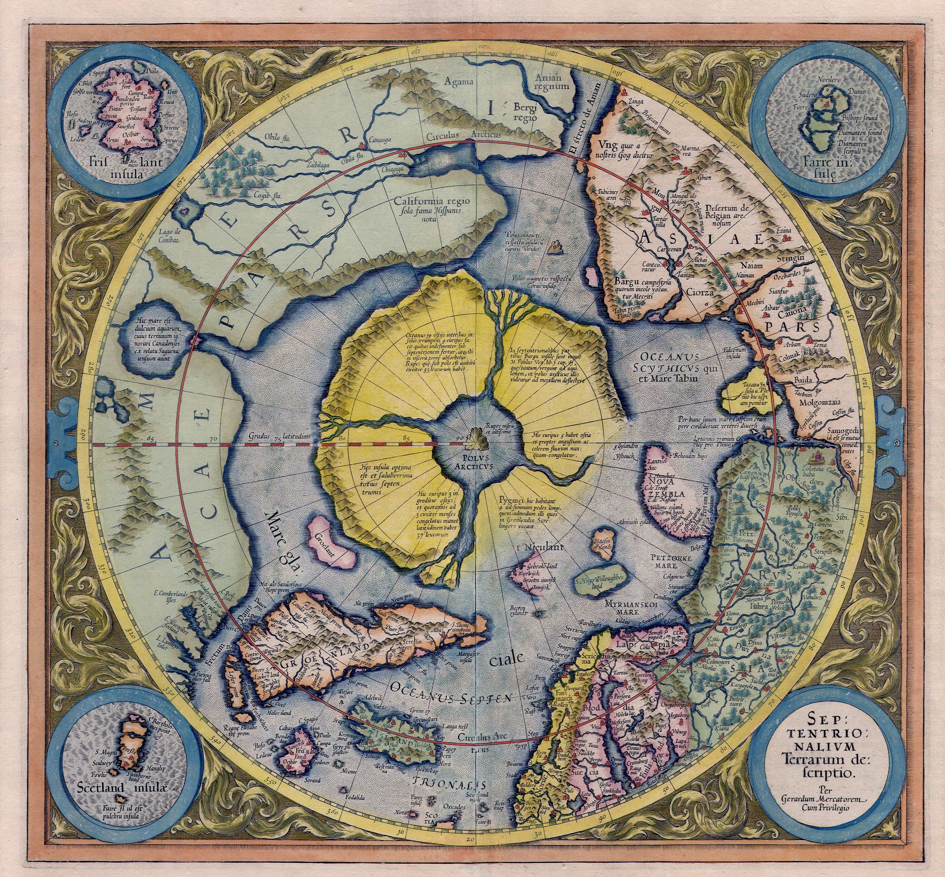
Flat Earth Map – Monte, Urbano (1544–1613)

Arctic continent on the Gerardus Mercator map of 1595
Giovanni Domenico Cassini / Jean Baptiste Nolin: Planisphere Terrestre … 1696

Map of the heavens and the earth – 1699

Planisphere Terrestre, Suivant les nouvelles Observations des Astronomes – 1713

Planisphere Representant Toute L’Etendue Du Monde Dans L’Ordre Qu’on A Suivi Dans Ce Livre – 1790

Middletons Pioneer Map of the World, plane and immoveable – 1876

Alexander Gleason’s New Standard Map of the World Flat Earth – 1892
 LINK – 31.4MB version
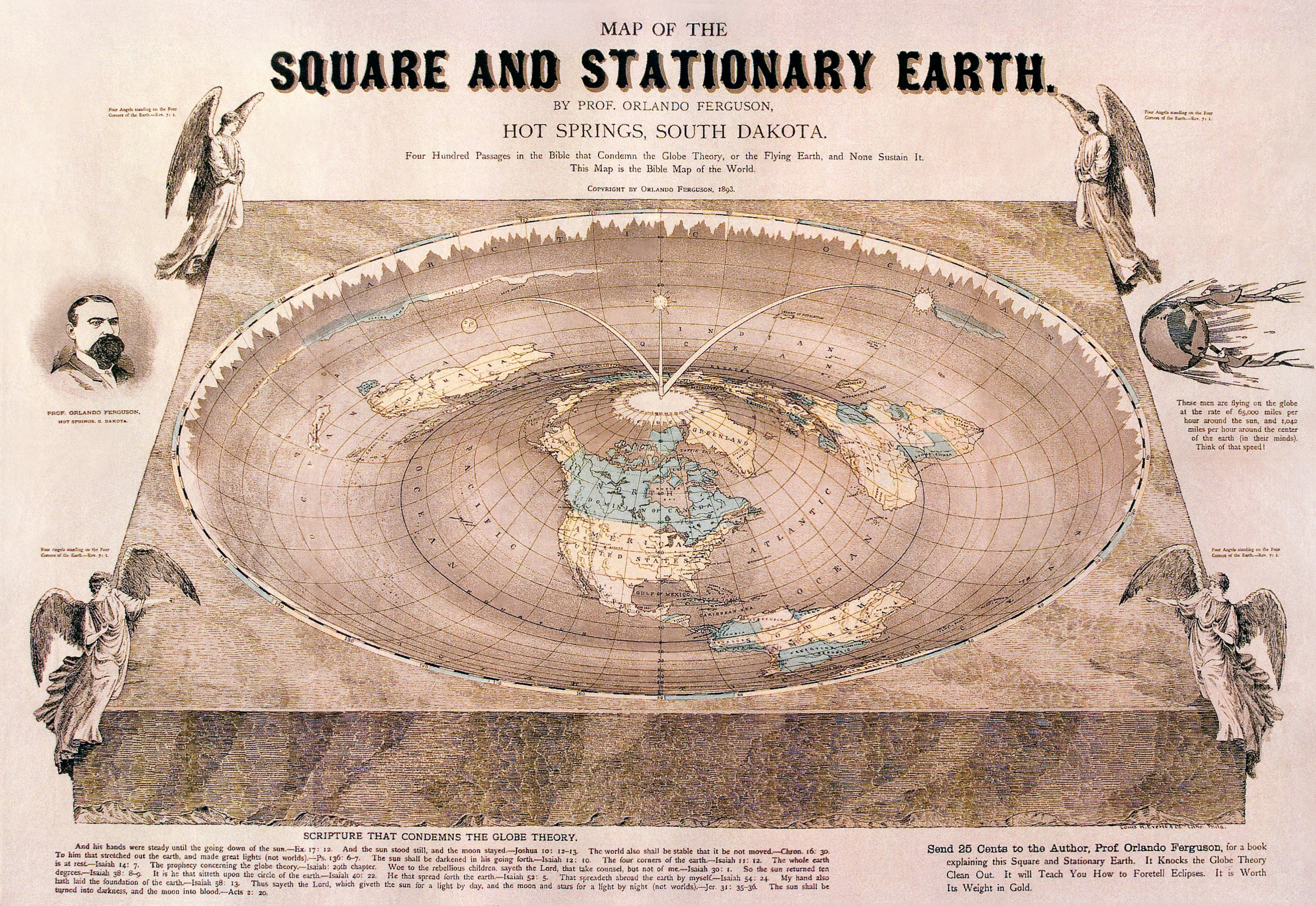
The Orlando Ferguson flat earth map – 1893
Canadian Arctic Expedition Map 1913

Air Map of the World Polar Azimuthal Equidistant Projection – 1943

CBS American School of the Air – Air Age Map of the World

Hammond’s AIR AGE MAP OF THE WORLD – 1953

The New correct map of the flat surface, stationary earth by John George Abizaid (1920).


The Flat Earth Society Map (Charles K. Johnson)

The General Map of the World by the Flat Earth Society

World Polar Azimuthal Equidistant Projection

Various other maps


Dictionary.com –
define map : a representation, usually on a flat surface, as of the features of an area of the earth or a portion of the heavens, showing them in their respective forms, sizes, and relationships according to some convention of representation:
I think we can all agree these are maps.
LikeLike
I think we can agree these are flat earth maps!
Naval navigators use a flat map
Aeronautical flight engineers use a flat map
PreGPS, auto drivers used a flat map.
Just another Co-Incidence theory, i guess.
LikeLike
I believe you may have missed or avoided the main point; every map is a flat map. Globes are clumsy devices to carry around, and don’t scale very well.
Local geography in my city and state is easily navigated by a projection of the earth onto a flat surface, eliminating hills, depressions, curves, and whatever reality the landscape has.
I would simply call these flat maps of earth. Of course with GPS today, I can pinpoint my current location quite precisely, as long as I have the signal.
LikeLike
lol.. the earth is flat bcoz the map is flat.
its like: Drive like maniac is ok since no problem if i crash in my simulator
LikeLike
Many of the map links are broken. 😦
LikeLike
alert(‘yeet’);
LikeLike
There’s not enough information in the world to convince a person the Earth is a flat plane until they are actually ready to see it…to overcome the horror of the force fed lie and break through the brainwashing program. It was a gut wrenching experience for me. I didn’t want to believe it at first. But when I took time to look inside myself, to question the science world, I could clearly see the deception. Lose your fear people. Open your eyes, your hearts and your minds. And you will need scientism just as much as you need organized religion.
Go into nature. Seen the work of the creator. Same as you fellow Flat Earthers out there. Take a break for tre computer screens once in a while…
Love and respect to you all. x
LikeLiked by 1 person
Back at ya AJ. I am fortunate enough to be IN Nature and grieve daily for the loss of flora and fauna I see dying everywhere due to our collective willful ignorance and general apathy. Somehow all the FE subjects though have allowed me to accept this lot in life and know their is a very, very long ongoing process here and we are the ones to make the change we must see to save ourselves from ourselves.
Love and respect to all,
J.
LikeLike
bla bla bla..
do explain eclipse if the earth is flat
do explain why i cannot see the sun all day long.
do explain what happen if fly to the west, i’m into space or hit your wall of stupidity?
LikeLike
DO YOU REALIZE THAT ALL THESE MAPS YOU ARE SHOWING ARE A FLAT (PLAN) REPRESENTATION OF A SPHERICAL PLANET ?! Even the name tells you : “PLANISPHERE” – STOP using these as a reference for FLAT EARTH! please !!! EVERYBODY
If The earth is really flat, it’s map should be very different than any of these.
LikeLike
Wow D, try to calm it. You say that the FE maps are a representation of a spherical planet. Would you consider that perhaps the Flat Earth maps were bastardised to fit the globe. As neither of us were around in those days it is hard to be categorically correct, is it.
LikeLike
Let’s have a race. Santiago, Chile to Perth, Australia. You fly north and I fly south. You must fly a route that conforms to your flat earth model, i.e., you refuel in Los Angles. I fly a route that conforms to the globe model, i.e., I might refuel in Sydney. We both fly Boeing 777 or other long-haul aircraft. I am guessing you won’t win. I am willing to bet my flight will be half the length of yours.
LikeLike
this kind of critical question make flat mind difficult to counter. Give them some poem or beautiful word so they can continue masturbating with their flat sensual attraction
LikeLike
Yea, I was looking along the same lines. I live in seattle, Its 7 hours to Reykjavik, and seattle to new york is 6.5 hours and new york to Reykjavik is 5 hours.
H = 7
A*A = 42.25
B*b = 25
42.25+25 = 67.25
root if 67.25 = 8.2
its off by 17%
LikeLike
That would be a great idea but if you think, you can just fly around anywhere you want you’re an idiot. Why do you think they have flight controls and you have to submit an IFR flight plan before you can take off?
LikeLike
I have to give kudos to whoever drew the 18th map from the top. At least they got one element correct in that the relative sizes and shapes of the continents are basically correct. But of course when you do that, then the distances and directions between the continents becomes even more distorted than on other flat earth maps. You basically have to rob Peter to pay Paul to get a flat earth map to work, and no one has come close to showing all of the relevant info in something close to an accurate representation.
Again, forget about surveying and fancy math…..just draw something that even roughly works with all of the available flight data and I will be speechless and as the saying goes, I will eat my hat! (I must have a chocolate hat around here somewhere 😉 )
Looking at this map, they have what looks like the equator passing through Mexico, India and China!!! It is probably more like the Tropic of Cancer which does pass through those countries, but also crosses Africa much further North than shown on this map. The distance from the North Pole to the Tropic of Cancer is roughly 4,600 miles. Using that as the scale of miles, the distance from Sydney to Santiago would be roughly 16,000 miles and yet Quantas flies there nonstop in about 12 hours without crossing North America as required on this map. That works out to about 1300 miles per hour.
Then Johannesburg to Sydney is around 13000 miles and again Quantas flies that route in a little over 11 hours nonstop, again without crossing over land. These calculations would result in even more extreme distances if the darker line of latitude on the map is meant to be the equator. Then it would be over 18,000 miles from Sydney to Santiago, and over 17,000 miles from Johannesburg to Sydney. You’ve got some splainin to do , Lucy!
Maybe Quantas has some really fast airplanes!!
The map also shows Antartica as being very close to Australia and the tip of South America. The gap between Australia and Anartica is shown as being about 150 miles when the closest distance between the two is more like 1700 miles as shown here: http://www.antarctica.gov.au/__data/assets/pdf_file/0006/149172/circle_distances.pdf
More splainin to do, Lucy! After all on a flat earth, 150 miles would mean you could see the ice wall from southern Australia, just like Sarah Palin could see Russia from her house 🙂
Do some similar calculations on all of the maps that show Australia and you will see that these maps are so ridiculously distorted that they basically prove that the earth is not flat. If you want to prove the earth is flat, then show me a map where the size, shape and distances between continents is consistent with the flight data here: https://flightaware.com/
LikeLike
maybe YOU”VE got some ‘splainin’ to do Lucy!!!
signed, Desi Flat is Definitely where ITs AT”
LikeLike
That map is from the 1940s and there were no nonstop flights on the routes I mentioned above. Measure the distances on the map you linked to and you will quickly discover that it is as inaccurate as the others on this page.
I mean the page you linked to actually quotes the maker of the map as follows:
“It points out that because the earth is a sphere and maps of the world are flat, every type of map gives a distorted picture. On a Mercator projection, now commonly used for world maps, the distortion increases according to the distance from the equator. For instance, Greenland is shown as being about the same size as South America, whereas its area is only about one tenth of that continent. Distances between widely separated places also become exaggerated, particularly in high altitudes.”
So they are admitting right up front that their map is based on a spherical earth and therefore is distorted as always happens when plotting a 3D object onto a 2D surface.
It seems the link argues for my position that you cannot draw an accurate map of the flat surface of the flat earth….because the earth is not flat! Drawing a 2D map of a roughly 2D surface is relatively easy compared to mapping a globe onto a flat surface, and yet no one has come close to accomplishing this relatively simple task!!
LikeLike
I see your points. I think all is psyops and I don’t think we have one accurate map of a Flat Earth, by design.
The map was created from and London centrist POV, the HQ for Psyop deception since King Charles II….but shows a Flat Earth map.
AS for the distances, I’m not sure what to make of them. That’s why we call it re-search.
LikeLike
Again, read the description of the map from the map’s creators. It is not intended to show a flat earth, but is intended to show a spherical earth on flat piece of paper. Hence all of the distortions in the distances and shapes of the continents which appear on all flat maps of the earth, and which they have already admitted to on their map. They do not ever claim that their map shows that the actual earth is flat, and in fact they claim the opposite.
If the earth was truly flat, it would be a relatively simple matter to plug in all of the distances between several major airports and paste in the continents according to their well established sizes and shapes. No “psyops” operation could prevent you from doing that right now with some graph paper and a ruler. The only reason there is no even remotely accurate map of the supposed flat earth is that the earth is actually a ball shape.
Meanwhile, all of the continents shapes and sizes, directions between continents, distances between all major airports, and the accurate longitude and latitude used for all kinds of navigation all work perfectly as mapped onto a globe.
One model works perfectly. The other model is much simpler to create, and yet no one has ever come close to representing it accurately. There is a simple explanation: the round earth model is correct because the earth itself is round.
There are over 100,000 commercial airline flights every day, so over 3.5 million a year. The data for most of them is on the flightaware website. What prevents you from doing some re-search for yourself and discovering that all of the maps you have presented are incredibly inaccurate?
LikeLike
Again, ALL maps are inaccurate. I’m not sure your point here.
Why would you use flat maps, if on a ball?
Why would the world cartographers declare the Mercator projection was “grossly inaccurate”, if we lived on a ball earth?
Fact is, they use a Flat Earth projection for flights, not a round spinning sphere, as would be if we were truly on a globe. I think your whipping a dead horse here.
Planes never adjust for the curve, because it’s FLAT
Planes never pick up time, or lose time in the air when a ball is allegedly spinning West to East…because it’s FLAT
There are no direct flights from the Eastern US to Africa…because Its FLAT.
Sometimes you have to just take basic facts and not go by published flight times and fake GPS readings, or get on a plane and measure for yourself.
LikeLike
It’s not a globe, its a plane.
Sea (SEE) Level. Plate TEctonics. Aero-plane…Sunrise, Sunset…GETIT?
Why do pilots never adjust for curvature then?
Why don’t we get to destinations faster flying East to West and never get to a destination, like SF to NYC flying at 500 mph when your alleged “round spinning ball” is supposedly rotating at an incredibly 1,000 mph below the plane?
Why does it take 15 hours to go across the Atlantic?
I’ll humor your response one more time and i’m done here.
“The shortest “direct flights” from NYC to Johannesburg, SA take 15 hours! to go across the pond of a few thousand miles? Riiiiiiiiiiiiiiiiiight…
time to move on Nirmala..you’ve shown your hand.
thanx.
LikeLike
All maps are inaccurate except one: a globe. Flat maps are simply easier to handle and refer to, but navigators have made adjustments to accommodate the distortions on flat maps for centuries. And Mercator maps are inaccurate because they are a flat representation of a round object. The distortion is proof that the earth is NOT flat!
Flights now use computer generated flight paths created on a spherical model of the earth, such as this one: http://www.greatcirclemapper.net/en/routes.html
Again the flight paths and distances calculated on a globe match the flight paths and distances caluclated on the site above and as shown on the flightaware website. Do you honestly believe that all of the airlines are in on some grand conspiracy and so misrepresent their flight times to fool us all? Wouldn’t their customers complain vociferously if the actual flight times were radically different than what their own websites show?
What makes you think there are no nonstop flights from the Eastern US to Africa? There are several listed here: http://goafrica.about.com/od/africatraveltips/a/Direct-Flights-From-The-Us-To-Africa.htm
The atmosphere is rotating with the earth, so while there is a slight coriolis effect that does affect airplanes, it is slight. This is why two people sitting on opposite sides of the aisle on a jet can toss a ball back and forth without it ending up at the back of the plane. The air in the cabin is moving with them at 500 mph. Fortunately the airplanes can adjust in flight, and no you would not feel it on the flight as both the coriolis effect and the curvature of the earth are so slight over shorter distances that the correction would not be noticeable.
LikeLike
Dude(ette?),
You need to buy my book and self-educate, you’ve drunk way to much of the PTB Kool-aid
“This is why two people sitting on opposite sides of the aisle on a jet can toss a ball back and forth without it ending up at the back of the plane. The air in the cabin is moving with them at 500 mph”.
Earth is not a tin can in the air
Earth is protected by a metal shell
Stick your friggin’ head out the window of plane and toss the ball to your friend
“coriolis effect and the curvature of the earth are so slight over shorter distances that the correction would not be noticeable.
What does the Coriolis effect prove on a spinning ball going one way at 1,000 mph? Which way does water spin at the Equator? Static?
get real!
“Earth is “too big”?
Can you do simple spherical geometry of miles x miles x 8 inches to measure the curve! At the ocean you should see 66 ft. of curve, but don’t see a crest or fall off, no matter how high you travel in the air as well.
On a 500mph flight, according to spherical geometry, you would have to dip the nose one-half mile per minute traveled, yet the aero PLANE remains level for hours!
LikeLike
This will be my last comment also. I answered your question about why flight times are not that different when traveling east versus west. The atmosphere for the most part is moving with the earth at the same speed (and by the way, 1000 miles per hour only applies at the equator). However, there is some effect and that is what causes the prevailing winds on earth which are generally west to east at the moderate latitudes where most people live in the Northern Hemisphere. So the flight times do vary because of these winds which are caused by the rotation of the earth, and that is why when I fly from west to east within the US, the flight time is less than the return trip. See this video: https://www.youtube.com/watch?v=3gNkgj9h2oM
Measure the distance from New York to Johannesburg on a globe and you will see it is much more than a few thousand miles, in fact it is 7,969 miles. However, the distance from NYC to London is 3470 miles and you can fly there in 6 hours….across the same pond. In case you did not notice, Africa is a lot further south than London and so the distance is further. And of course London is further North than NYC.
Besides, all of your flat earth maps also show the distance between NYC and Johannesburg as being much further than between NYC and London, so what exactly are you arguing here? It still makes sense that the flight takes longer. Checking the most common flat earth map, the distance is over 2 and 1/2 times as far. And just to be clear, flight times along mostly north/south routes would be roughly the same on both a globe and an azimuthal projection as the one part of that kind of map that is correct is north/south distances. This is from Wikipedia:
“The azimuthal equidistant projection is an azimuthal map projection. It has the useful properties that all points on the map are at proportionately correct distances from the center point, and that all points on the map are at the correct azimuth (direction) from the center point. A useful application for this type of projection is a polar projection which shows all meridians (lines of longitude) as straight, with distances from the pole represented correctly.”
and:
“It is useful for showing airline distances from center point of projection and for seismic and radio work.” (This is why the airline map you shared was created as it used London as the center point instead of the north pole and so flights to and from London were shown relatively correctly on that map.)
It is east/west distances that become distorted on a polar azimuthal projection, and more so the further south you go. That is why Australia looks so elongated on the projections used by flat earthers, and why Sydney to Perth appears to be more like 5000 miles on a flat earth map, when you can fly between the two cities in 5 hours. Again not all distances on a flat map are wrong by the same amount (and due north/south flights including polar routes traveling near of over the north pole would be fairly accurate), but no distances as they appear on a globe are wrong. You can test this by stretching a rubber band between any two major cities on a globe and then comparing the distances measured to the actual flight distances. See this other analysis: http://creation.com/a-direct-test-of-the-flat-earth-model-flight-times
As for sunrise and sunset, perspective does not cause the object perceived to only drop lower when distance increases, but it would get smaller. In contrast the sun drops much lower and even disappears completely without getting smaller. Here is another video:
Thanks for the dialogue. I do appreciate exploring this with you.
LikeLike
OK, one last point: level on a spherical earth has to do with the distance from the center of the earth. It has nothing to do with a straight line extending off into space. So a plane would remain perfectly level if it stayed at the same altitude during its flight as it’s distance from the center of the earth would remain the same. No dipping required.
LikeLike
Center of the Earth, seriously? WE’ve only drilled down 8 miles into EArth, how the heck can you know the center of the EArth, or what it is made of?
So a plane goes around a ball and doesn’t fly off to space because its measured from a center we have never been to or can measure?
This makes zero sense at all.
LikeLike
A much more thorough discussion of the irreconcilable differences between actual flight times and the distances shown on all flat earth maps is here:
https://www.theflatearthsociety.org/forum/index.php?topic=69921.0
LikeLike
Good Stuff,
I included the two versions of FE from your link
Thank you.
LikeLike
Yes, the bipolar model solves one problem with most flat earth maps, which is that they show Antarctica as the mythical ice ring surrounding the earth and holding in the oceans. Instead the Bipolar map shows Anarctica as a continent.
But while the distances are different than the unipolar maps you have shared, they are still inaccurate. And of course the map does not explain either why the water does not flow off the edge of the flat earth, or what is holding it in place. Or if the earth is an infinite flat plane, then why throughout human history has no one ever traveled beyond the edge of that map?
The path of the sun is much more complicated to lay out on the bipolar map and also, it is not just a “path of the sun” problem with the bipolar map. There are times of day when both eastern Asia and the United States are in daylight, and Europe and Africa are in their nighttime. How do I know? I speak with clients all over the world and so am very familiar with time zones and when I can and cannot reach a client from here in the US. For example, right now in March, when it is 3:00 pm in NYC, then it is 4:00 pm in Buenos Aires, 6:00 am in Sydney, 7:00 am on the Kamachatka peninsula in Eastern Siberia, 8:00 am in Auckland, 9:00 pm in Madrid and Cape Town, 10:00 pm in Moscow, 3:00 am in Beijing, and 12:30 am in New Delhi.
In order for that to work on the bipolar map, the darkness of the night would be located in the middle of the map slicing diagonally across Africa and Europe and much of Asia (but not all of Asia), while the left and right sides including North and South America, Hawaii, Australia, New Zealand, and far eastern Russia would be in daylight. Japan and China would be in darkness while Australia and Eastern Siberia would be in daylight. That would be quite a trick with just one Sun. Really, how do Australia and Eastern Siberia manage to be in daylight when China and Japan are between them on the map and yet would be in darkness?
Maybe there are two suns…and the reason we can’t ever see both at the same time….is…..because…..?
Actually, the more I look at the map, I see that the area of daylight forms a very large circle that encloses the area of darkness on the map….how the heck would that work?
At least the unipolar map does not have this problem of a circle of sunlight enclosing an area of darkness.
PS: It is also daylight on Wake Island, east of Japan. It clearly completes the circle of daylight surrounding the areas of darkness on the bipolar map.
Bottom line: no flat earth map comes close to accurately representing the surface of the earth. Every globe does accurately represent the surface of the earth.
LikeLike
I would definitely buy one. But can’t seem to find any 😦
LikeLike
To: Nirmala and the others who buy the party line: Several errors you have each made here; too numerous to outline.
But a clue to help you out: From the top of This Very Web-page, Maps 18 (“General Map of the World by Flat Earth Society” for reference; it is easy to miss the count) 22, 25, & 27: EACH ARE DISTINCTLY Different than the other maps located herein, and elsewhere: Did you Not Examine them? They are true 2D proportionate maps of a 2D world, NOT Projections of a sphere on a plane. LOOK at them…
(I’ll wait…)
Now, Did you notice the continental proportions? No distortions. None. All is in actual perspective, relative to each other, for each latitude and longitude marker, unlike everything else on the Web~
Nirmala’s quote is an eye-roller: “these maps are so ridiculously distorted that they basically prove that the earth is not flat.” Umm, No: What is “Distorted” does Not “prove” anything, especially “ridiculously so.” Did you check your logic at the door? Retrieve it; perhaps it’s still there. You’re going to need it back.
As to flight times and distance discrepancies per MAPS(!), both “teams” have their videos “showing” the other view is wrong. Each argument must be examined to determine veracity, if there are no fallacies; which, sadly, there are.
To: CM Mick Boudreau: “You’d be guessing” all right. And… you’d still lose the bet. Quantas doesn’t actually fly to or from Santiago, Chile to Sydney, Australia, or anywhere across the “Southern Polar Region.” Don’t believe me? Book a flight. Hope you have $42K – $75K for the empirical experiment… No flights occur. None. Try it. It will cancel well before the flight and you will be notified. Only ONE owner of Southern polar regions flight websites operates them all. There’s 150 of “them there” services, but only 5 people involved. Look it up. It’s as close to a scam as you will find, but only if you look into it…
“aj”: Kudos to you! Well said, well spoken, and politely, too. That’s important. Civilized gentlemen should be, without the name-calling that is rife on internet forums & comments…
Empiricals:
1) On even a semi-clear day, one can stand at North Lake Tahoe’s shore and see South Lake Tahoe’s shore and buildings, 40-ish miles away. With a curvature of ~50ft drop every 10 miles, this would not be possible within one’s Field of Vision. South-Shore should be 200 ft below your Field of Vision. Thus, the lake’s water is FLAT. Water doesn’t curve. Go there: Look at it. Use binoculars.
2) From Miramar Beach in So-Cal~ one can see, with HD cam, Habitat Oil-Rig, 9.1 miles West. The curvature should drop 44.57 ft below our Field of Vision, but we plainly see the pylons in the water supporting the Rig. This is not possible with a curvature. Thus, the ocean’s water is FLAT. Look at it. If it is FLAT there, does it perform a “sheet bend” somewhere else at a 20^ or 40^ elbow to make up for it here? Don’t think so…
Don’t like water? Alright.
3) From the upper Cascades, on a clear day of climbing, you can see the Rockies, ~1350 miles to the SE: This would be a drop from Field of Vision due to curvature of 6,750 ft. But the Field of Vision doesn’t drop. Thus, it’s FLAT from the Cascades to the Rockies. Thus, not only the water, but the Land is FLAT. Look at it. Use binoculars if you don’t have 20/20 vision and a pristine, clear day.
Question: When the NASA-NAZIs tell you one thing, and you observe another, What do you believe? And Why do you believe it?
Remember folks, with a FLAT Disc Earth, the ~8000 mile diameter equator of a sphere becomes an (~8000 X PI) = >25,000 mile Diameter CIRCLE-DISC, so there are a LOT of square miles to account for; this place we live upon is HUGE! [>25K miles across is an area of (PI*R*R) = Half a Billion Square Miles: Gasp!] We simply CANNOT see it all. Observation of its totality fails. So why the pride & arrogance as if you can, or as if you’ve “made every calculation” yourself, which you DIDN’T…? You merely accepted the revealed propositions of an “authority:” That is Argumentum Vericundium, a logical fallacy.
But I wish to be helpful here, so…
Here’s a $50,000 college education graciously Given to you in a Ten-Word Lesson:
“Believing revealed propositions is the philosophical method everyone actually uses.” crl.
Yeah,You’re Welcome.
Most sphere-earth arguments devolve into the form, Q: How do you know? A: NASA told me so… (Did you realize that NASA’s last photograph of Earth was from 1972? Everything since is a “photo-shopped composite image”… ask them. Call them on the phone and ask them. Bear in mind, some have said: NASA stands for “Never A Straight Answer…” )
Well, some of us have a differing authority.
Isaiah 40:21-23 “Have ye not known? have ye not heard? hath it not been told you from the beginning? have ye not understood from the foundations of the earth? It is he that sitteth UPON THE CIRCLE OF THE EARTH, and the inhabitants thereof are as grasshoppers; that stretcheth out the heavens as a curtain, and spreadeth them out as a tent to dwell in: That bringeth the princes to nothing; he maketh the judges of the earth as vanity.” VANITY…
1st Chronicles 16:30 “Fear before him, all the earth: the world also shall be stable, that it be not moved.”
The Earth is a CIRCLE, and it does NOT MOVE: the world is STABLE.
Food for ‘Thot’ > *IF* the Earth moved — 1042 mph in a rotational spherical spin, Plus 67000 mph in a very large orbit around the Sun, Plus whatever speed the Sun and its solar system members are traveling around in the arm of the galaxy — then when the Apollo mission astronauts, free from Earth’s atmospheric influence, traveled “back” at 18000 mph, when would they actually “catch up” to the Earth? Um, the next year? Yes, Virginia, NASA strikes again. Strikes out, that is…
(How do you know anything about this massive Earth you live upon? NASA told you so? You do realize they have a vested interest? “Gleaning tax dollars for over 50 years…”)
If the Earth moved so much, in so many different directions, does the Almighty mock us, when He bids us: “Be STILL, and know that I am God…” ? Psalm 46:10.
Tuf to “be still” if the Earth is moving around at breakneck speeds as the globalists would have it…
Peace. Ciao for now.
LikeLiked by 2 people
Great Rant! Well done.
LikeLiked by 1 person
Ok, so the maps you reference above have the shape and relative size of the continents correct, which is easy enough to accomplish by copying them from round earth maps that are designed to show that info correctly (search authragraphic projection), but all of the distances between land masses in the Southern Hemisphere are still ridiculously wrong. There are direct nonstop flights from Australia and New Zealand to South America that arrive in way less time than the roughly 20,000 miles represented on those maps would allow, given the speeds of modern commercial aircraft. Check out Sydney to Santiago on http://flightaware.com/
Quantas flight #27 makes the trip several times a week in a little over 12 hours. Not possible on any of the maps you reference.
I do like water. Here is a well documented experiment showing that distant objects do drop below the horizon with increasing distance: https://www.youtube.com/watch?v=MoK2BKj7QYk
Here are the results in a nice chart: https://www.flickr.com/photos/138443523@N08/32177485004/
Where is the documentation of your claims?
LikeLike
Thanks for the Kudos, “jwlpeace.” I heartily appreciate it ! (I can post here, but they won’t let me “Like” another’s post, so I’ll just write it for ya.)
Thank you for the response, Nirmala. I do appreciate the dialogue and interchange. Good to have another mind to interact with, from a differing point-of-view that challenges our own worldview, eh? -Worldview- literally intended here, of course.
You asked for documentation. I wrote down my findings and posted them. Thus, I documented. That which is written down is documentation. This is true, whether it is raw data, or data plus interpretation leading to conclusion/s. Perhaps you desired links to previously posted information? Then: Stay tuned…
If you have not availed yourself of “Only a Paper Moon,” an older video wherein the data is provided by NASA itself, you owe yourself the treat.
Link: https://www.youtube.com/watch?v=11SsXYUUHSs&list=WL&index=40
Yet I hesitate to add more links, as I had hoped this would not become a matter of “Who can cite more You-Tube videos,” as I implied in my first post on times & distances. This is *Why* I gave real-world observations. Even still, as I wrote in a college paper way-back when, “Observations don’t come with explanatory tags: they must be interpreted. This requires a mind, or spirit. And every mind is presuppositionally-biased when it performs any hermeneutical function.” If we use fancy computer-enhanced charts, the input and the words of interpretation along the way are purely human, as are the conclusions. The computer adds no philosophy of import.
Thanks very much for the links to yours, Nirmala. My Comments on them:
First in order of your post — I’m a bit disappointed: You didn’t take my challenge, did you? I addressed the Santiago, Chile to/from Sydney, Australia flights in my first post. The flights you cite don’t exist. Try them. Quantas doesn’t actually fly them “several times a week.” The distances are Not “ridiculously wrong” as you are once again premising a spherical Earth, and the shape of the Earth IS the point at issue. More to that logic later this post…
Your second link was referred to also in my first post, “…both “teams” have their videos “showing” the other view is wrong. …” I will provide the counter link below. Both videos cannot be true, or else the Earth is a shape no one has guessed at yet…
Turning Torso, the 1st image on the Flikr Photostream I was taken to in your 3rd link, led to a composite of overlaid photographic shots to simulate the desired view, not prove any point on curvature. The parameters I needed to determine anything about what was being said were missing. The columnar structure seemed contrived in this way. That is, the photo had subset photo-overlays upon each columnar shot, blocking the view of what was actually photographed. This is Why I mentioned in my first post that NASA’s latest actual photograph — a light-exposed and recorded, chemically-developed paper that can be physically examined for any alterations after the exposure — was 1972: all later NASA images are “photo-shopped composite images,” as the engineers say “they must be to provide the clarity the public demands.” Photographically Real Shots are “too grainy,” in other words. As well as incomplete, for not one of them captures the whole, as also indicated on my first post. Perhaps I misinterpreted the chart altogether that you provided (returning to the Turning Torso topic); humbly, I admit I could have. Yet the provided parameters were bleak.
Other than a couple of actual shots as exceptions — to be discussed in a moment — the rest of the collection of charts and graphs were all composites; even the Graphic Arts program that seemed so technical, replete with the impressive “graph-paper look” were just drawings on an advanced Graphic Arts platform, not a real world scenario, sadly enough. I am familiar with the “magic” of graphic artistry. Impressive to onlookers, but that’s what they’re designed to do; it is still not Real. ( Ah, technology; I love it when it works, no? Yet the pragmatic can be so subjective, yes? Purposes, purposes; who has the right purposes…? Editorial tangent.)
The exceptions: There were two photos, one taken at 320 feet with a red-line drawn across the photo, and one at an un-noted height at a beach (with vehicles parked nearby, for reference), with a red-line drawn across it. Yet, this is suspicious in itself, for each, for no one can see, actually “see” curvature at a mere 320 feet. If they do, the eyes should be checked. The line overlaid may very well be inaccurate; we’ve all seen optical illusions fool our eyes before. And who can draw a straight line? No, really.
Contrast that with this: https://s-media-cache-ak0.pinimg.com/236x/ea/56/9d/ea569d98c733ade1d90e5a2c780fc1d2.jpg = A 720 mile horizon from 343,200~ feet up, and NO curvature. No wonder we call it a HORIZON, from Horizontal, a STRAIGHT FLAT LINE, not a “Curvizon,” eh?
Note Well: SR-71 jet aircraft travel to 110,000 feet and beyond: yet those pilots can’t see curvature. Except for the curved glass thru which they look, of course. Link to jet aircraft video: https://www.youtube.com/watch?v=8s18dQOb9gM
Lake Pontchartrain Causeway, 27.87 miles long = 380 Feet of missing curvature: http://2static.fjcdn.com/large/pictures/aa/48/aa4828_5842354.jpg
Link to Miramar Beach, in my faraway beloved Cali~ of an actual HD video cam stationed at 1 foot elevation above sea level, all which CAN be seen for yourself, showing the Habitat Oil-Rig out at 9.1 miles from shore; the “curvature chart of a global Earth” is consulted here, and 44.57 feet is NOT accounted for in our Real observations: WHY NOT? https://www.youtube.com/watch?v=vP7lyAKNpj4&t=2s&list=WL&index=79
Then, the HD cam heads up the steps for a 35 foot increase in elevation. This higher perspective “should” allow for a greater Field of View upon the Oil-Rig, assuming the premise of a curving-horizon Earth. Yet it doesn’t change the View of the Oil-Rig. Thus, the premise of a curvature is false. Please don’t let the import of this escape you — The Argument of the Logic is Valid:
If P, Then Q;
Not Q:
Therefore Not P.
Modus Tollens. aka, Hypothetical Destructive Syllogism.
To argue in the opposing fashion, which several of the charts on that link you provided tacitly did, assumes the very point at issue. That begs the question. The “red-line” shots assume that no other factor could produce the visual effect. This is Asserting the Consequent, another fallacy.
Finding the right premises is always the tricky part, to be sure. (I noted that the Biblical documents were left untouched; yet these are premises, too, are they not?) Yet one thing is always true and dependable: If you premise your “intended” conclusion, then no argumented reasoning outside the circular (or is that spherical?), no learning, no advancement takes place. Don’t let this modern Irony evade you; a Flat-Earther is telling you that through your arguments, “no advancement takes place.” From your perspective, That has got to be the most humorous thing you’ve read all day, no?
Since we’re discussing the shape of the place we all live upon, would I not be remiss on this day not to say HAPPY EARTH DAY ? (I just had to say it…)
LikeLiked by 1 person
I will just share a few points, and thank you also for this discussion. I always appreciate the sharing of views different from my own.
I do not know what evidence you have for your claim that Quantas does not actually fly the route from Sydney to Santiago. This page on the flightaware site has the recent history of flights completed, and if you register on their site, they give you 4 months of records:
http://flightaware.com/live/flight/QFA27/history/80
I can book it today on Kayak.com for $880: https://www.kayak.com/flights/SYD,nearby-SCL,nearby/2017-05-28
There are also regular flights from Aukland to Santiago on LAN airlines:
http://flightaware.com/live/flight/LAN800/history
More documentation is on this thread including a video taken on the Aukland to Santiago route: https://www.metabunk.org/flat-earth-theory-debunked-by-short-flights-qf27-qf28-from-australia-to-south-america.t6483/
Other flight times and distances also do not compute as calculated by another person from a Christian ministry that explored this: http://creation.com/a-direct-test-of-the-flat-earth-model-flight-times He also encountered many replies to his post suggesting that the flights he refers to do not actually happen, but he replies that he himself and several other people in his ministry fly them on a regular basis. See the comments for this discussion about whether the flights really are flown.
As for your video of the platforms, did the person doing the video make any adjustment for refraction? Cold air refracts light more than warmer air, and so the platforms would appear higher when filming from 1 foot above the water (through the colder air just above the water) than when filming at 35 feet elevation. See: https://en.wikipedia.org/wiki/Atmospheric_refraction
And why does more of the distant platform appear to be below the water during the entire video? The more distant platform should appear smaller due to distance as it does, but there is more of the underpinnings that are hidden. That should not occur on a flat earth.
The Flickr photo was a composite taken from the video in the second link for easier reference. If you want to see what was filmed without the overlays watch the video.
LikeLike
There is another thread on the metabunk site that was started by a Quantas pilot who flies the Sydney to Santiago route, and includes video he took from the cockpit of the 747 that shows the sea ice near Anarctica during his flight. He later matched up the shape of the ice to satellite photos taken of the same area on the same day:
https://www.metabunk.org/a-flight-over-the-antarctic-sea-ice-from-chile-to-australia-qf28.t8235/
And here is another thread that opens with another impossibility of the flat earth map: the Southern Cross constellation appears south of both Australia and Brazil at the same moment, when that is two almost completely opposite directions on the flat earth map. Are there two different Southern Cross constellations?
https://www.metabunk.org/debunking-flat-earth-with-the-southern-hemisphere.t7693/#post-184906
LikeLike
Good Job, and thank you. Einstein had many problems with his own mathematical equations regarding Earth, Time and Space. Tesla thrived on experimentation, not mathematics.
LikeLike
Full informative article which you have described Ultimate Flat Earth Map Collection.I gotten your Flat Earth Map Collection so I keep in future.
LikeLike
This is ultimately a war between 2 religions.
If the world is flat, then the Bible is true and there is a God, with moral laws, to whom we are all accountable.
If the world is round, then Humanism is true and there is no God. Man is the author of his own morality.
The former lives by the moral laws of God.
The latter lives by their own moral laws.
LikeLiked by 1 person
But bible got many errors and some books contradict with each other. How many gods do we have?
LikeLike
There is only one Bible. The Authorized version. Compiled from manuscripts handed down through the ages back to the Apostles of Christ. Preserved, without doctrinal error, just as God promised.
The hundreds of so-called “New” versions, compiled from Roman Catholic manuscripts, are imposters. Created by heretics at the behest of the Roman Emporer Constantine and rejected by Christendom over the ages.
But if that is what you want to use as an excuse for rejecting the Creator and His moral law, so be it. The list of excuses are endless. My favorite is “there is no God, everything came from nothing”. So it is to this nothing that they are accountable for their actions. Which is exactly what men who reject the will and Word of God want.
There is only one reason for man to reject God, It’s because he loves his sin and wants to remain in it. So he rejects the existence of God and puts himself in God’s place. Rejecting God’s moral law for the moral law of his own desires. The moral law of convenience. To be morally lawless.
If your conscience, the one your Creator gave you, compels you to make excuses for your rebellion to your Creator and His absolute moral laws, so be it. But I have better things to do than play that game with you.
Have a nice day.
LikeLike
Search4Truth,
And that would be the bible written by man.
It is impossible to escape the conclusion that the entire bible is a product of humans. There may be claims that is is the word of god or inspired by god, But the nature of these claims is that they too also come from a human.
That is, unless there is an explanation where the bible exists, where man is never a factor. Hmmm?
LikeLike
Ok. If you say so.
The Bible was written by men. Without any super natural influence. There is no God. The natural world brought itself into existence from nothing. It is to this nothing that mankind is accountable for his actions. Man is the author of his own morality. He can do what ever he wants with impunity. As long as he has good lawyers.
You win. Humanity loses.
Have a nice day.
LikeLike
I am expanding upon an e-book “Antarctica Does it End? Hast thou comprehended the breadth of the earth? Declare if thou knowest it all.”
Obviously, from the title it isn’t difficult to see that I am coming from a Biblical perspective. I only came to the conclusion that the earth is flat (or rather not a globe) back in December 2016. I found some of the comments above useful, because I have been asked about flight-paths and irreconcilable flat earth distances if the earth were truly flat. I believe that the maps we have at our disposal don’t give us the true picture. If only NASA could be relied upon to tell us the truth!
LikeLiked by 1 person
the reason i started to believe the earth was flat is it made more sense than the globe idea.we will never be able to prove the flat earth (we could but are not allowed access to antartica) nor will we be able to prove the globe earth.and this is my point,the globe earth is questionable and it shouldn’t be.with all the satellites and all the times we have supposedly gone to space we do not have one true picture of earth.they are definatley hiding something.
LikeLike
My only question to all the people that are NON flat earth believers. Have you ever seen the world with your own eyes to say how big every continent is and where they are on earth, how far are they apart what shape they are? If you can say yes you have personally lived to see it with your own eyes and not just a picture someone else took I will say you are right. I personally believe the erth is flat, nature proves it to me. If you want to live on a spinning globe be my guest but the stars never move at any time of the year yet the earth is always turning and spinning around the sun. If you want to know where north is, just look for the northern star. Any time of the year it will always be north.
LikeLike
Edited from above
It’s so weird how we can present evidence that the world is round and the flat earthers completely don’t get any of it so they claim that there is no real evidence. Here is proof that the earth is not the model that you FE’s claim it is…. the distance from sydney austrailia to santiago chile is only 7055 miles and takes a little over 13 hours to fly. You flat earthers believe that the edge of the earth is 70,000 miles in diameter, which there is no math in the world that can make these two facts correlate, either the planes are fooling us by making the flight in two days and their really just zonking out the passengers for two days and calling it 13 hours, or it really is only 7055 miles and only correlates with the fact that the longitudinal lines at the bottom of the globe are coming closer together instead of further apart. And just to put it into perspective, from bangkok thailand to orlando florida is 9535 miles and takes 18 hours to fly. They look like they are the same distance when you look at a flattened map of the earth, but in reality they are over 2000 miles different, and they represent more of the center of the globe and sydney to santiago represents the south end of the globe, so we can see that there is definitely a wider middle, which correlates perfectly with a globe earth and flies in the face of the flat earth, because according to the flat earth map bangkok and orlando should be closer to each other than
LikeLike
Tralay520 – I take it you have personally measured the distance and personally measured the speeds which is fantastic and just a quick one to add to it is that no matter how much evidence we provide round earthers with you still have the shallow perspective because someone told you something. Look at all the real videos taken by flat earth believers and compare it to the 1 actual picture of earth. What you believe now in 100 years will be something else.
LikeLike
It seems to me that the “trump-card” as it were that the “ball-earthers” think they hold is the airplane distances in the southern ‘hemisphere’. The mantra goes something like this: “On a flat-earth Sydney to Santiago would be impossibly long!”, I reverse the charge: “On a spherical-earth Sydney to Santiago would be impossibly short!”
The distance between the above two cities is reckoned to be 7063 miles, I believe this to be correct (most airplane route websites agree with this), so on a globe this distance would probably be nearer half that figure!
Some question this with: “If that be the case, how come planes don’t see/fly over the west coast of North America en-route?”, but just as the globe model certainly doesn’t give the true representation of our earth, the maps shown above are most likely way off as well!
Also, is it even possible to get high enough up there and survey the whole earthly scene in one go? Even if we could, we couldn’t take the whole picture in!
LikeLike
I do not think it is possible to take a single photo of the flat earth. A person can not get enough height. I believe they would hit the waters above and not have enough height for a single photo
LikeLike
What about the man years ago went up high and said, “it looked like a circle and had rounded up edges.” I believe Nasa could get a good picture, but won’t.
LikeLike
Well, I am considered an intelligent person by those who know me but this subject, which is fascinating me tremendously, is also causing me to feel really dizzy.
Is anyone willing to explain flat earth to me as if speaking to a child?
I really want to know. Angry people have me on the immediate alert and suspicious they are in the wrong. I am not aware of any ‘flat earthers’ who get angry?
LikeLike
CB, I certainly agree, some do get “very hot under the collar” on this!
I believe the reason that ” ‘flat earthers ‘ ” don’t “get angry” over this is because they were once previously deceived themselves.
I only became convicted that our Earth is NOT a spinning globe last year, and it really is a shocker when you realise we have been “sold a pup” so to speak. You really do begin to wonder WHO you can trust! Whatever will we learn next?
I was so taken aback about the whole thing, that I had to research further.
We are heavily reliant upon NASA for ‘reliable’ info on everything in this department, I was quite staggered to read an old recruitment advert of theirs (1960’s) for they really do give the game away! -look it up on Wikipedia; https://en.wikipedia.org/wiki/_Jet_Propulsion_Laboratory
It reads;
“When you were a kid, science FICTION gave you a sense of wonder. Now you can feel the SAME way just by going to work.”
Effectively NASA are saying “science FICTION beguiled you as a kid, now you can continue on this deceptive path as an adult just by going to work for us”!
This same NASA JPL laboratory was responsible for all the artwork and photo-shopped images from their 20 year Cassini-Huygens ‘mission’ which has just recently ended. We are asked to believe that this Cassini satellite covered some 3 billion miles without so much of a hiccup! Is there such a thing as a piece of man-made machinery that can exist for 20 years with no maintenance or fuel? It was only about 22′ x 13′ in size! If only our earth-bound cars were so wonderful?!
Can the moon be landed on? The ‘space-race’…
Anyhow, I cover these and many other associated topics in my e-book “Antarctica Does It End?” If you are interested, it can be read for free, if not, it is on Amazon at their minimum price schedule.
LikeLike
Globalists get angry because flat Earthers blaspheme their religion.
LikeLike
S4T (& colmford),
Angry? – that is often an FE tactic, when their baseless claims are countered with actual evidence.
The claim above about the Sydney to Santiago distance is an example; an empty claim with no substance provided. Air routes between these cities match globe distances, while FE distances (as well as continent shapes) are severely elongated in the southern latitudes.
See, no anger here!
LikeLike
“Evidence Please”, glad to hear that there is “no anger here!”
If you were to read my postings on this site you would know that I only came to believe in the “Flat Earth” less than a year ago. Until then I would have considered any person believing in a flat earth to be a “sandwich short of a picnic”!
But, why should the burden of proof rest on flat earthers? NASA have made an absolute pigs ear so to speak of everything in this department. Their ‘evidence’ is anything but! Photo-shopped images and artwork is all we get from them. As said in one of my postings above, I don’t dispute the time it takes for airplanes to travel from Sydney to Santiago. The Earth can’t be flat and a globe, it must one or the other?
Another thing, (and this does anger many) the flat earth belief confirms what the Bible says, for you will search its sacred pages in vain for just one verse that speaks of the Earth moving, yet some seventy verses that speak of the sun and moon rising and falling.
It has often been claimed that “modern science has proved the Bible wrong”, that is the oft repeated mantra.
Perhaps you would be so kind as to provide ‘evidence’ to the contrary?
I realise that being a Bible believer may not give me credibility among some, for many think it to be a book of myths! Yet this is our Creator speaking.
LikeLike
colmford,
Before branching into topics outside your “distance” post and my direct reply; might we address your claim about shorter GE distances. As I noted, air flight distances match up with globe distances.
For context sake, I’ll quote you:
[The mantra goes something like this: “On a flat-earth Sydney to Santiago would be impossibly long!”, I reverse the charge: “On a spherical-earth Sydney to Santiago would be impossibly short!”
The distance between the above two cities is reckoned to be 7063 miles, I believe this to be correct (most airplane route websites agree with this), so on a globe this distance would probably be nearer half that figure!]
Thx.
LikeLike
As I clicked upon your website while searching for FE maps cause I may be on to something it would only load 3 out of all the maps on your site for me. Just curious if anyone else has this problem or if there’s something wrong with your site.
Thanks
Eric
LikeLike
images not there for most, can this be fixed?
LikeLike
Links not working.
Here is a collection of maps!
http://wikys.com/controlled-beliefs
LikeLike
hey all those maps are like the Gleason map in different form tho lol. australia is way too far off to match up to miles distances from s america, s africa etc
LikeLike
can’t see any images!
LikeLike
I’m in Canada and I believe a new bill has been passed called bill c-11 that is not allowing me to view any of the map of the various section and a lot of the YouTube videos have been removed.
Unless these items have been removed from your site. 😦
LikeLike
anyone familiar with the free right to travel? forcing insurance on others is the ultimate hoax and kon!
LikeLike
anyone familiar with the right to travel? forced insurance is the ultimate skam/hoax!
LikeLike