
~ Hat Tip to Modern Gnostic
http://www.themoderngnostic.com/?page_id=55474

Satellites Don’t Exist

The origins of satellites came from the mind of famous science-fiction writer Arthur C. Clarke. He wrote The 1945 Proposal by Arthur C. Clarke for Geostationary Satellite Communications. Arthur C. Clarke was a high level Freemason as well as a homosexual and self-professed pedophile, throw in satanism and you’ve got a heck of a guy. Arthur C. Clarke was writing science fiction stories along with other notable sci-fi writers Philip K. Dick, Robert Heinlein and L. Ron Hubbard. Arthur C. Clarke did initially claim to know Hubbard, however later he denied that statement and thought L. Ron Hubbard to be completely crazy. That link to Hubbard had to be broken, all out rebuke works well.
There is a seven year overlap between 1945 to 1952 when Jack Parsons, L. Ron Hubbard and Arthur C. Clarke were all alive and were witness to the Science Fiction industry exploding into the eager minds of young people. I find the Roswell crash in July 1947 quite timely and it certainly propelled the interest in space to mania levels.Hollywood didn’t miss the cue since they’re owned by the Khazarian Rothschilds. Hollywood started cranking out sci-fi movies by the truckload. At the top of the Sci-Fi movie heap was the great undiscovered frontier — Space
The Khazarians saw an opportunity to make a ton of money by pushing the space meme. At some point a scheme was hatched to fake launch satellites into space for profit. NASA also became a tool to constantly remind humans of our insignificance in the boundless cosmic order. NASA has been beating the divinity out of us with pseudoscience, propaganda and spiritual delineation. In other words “control” Pre-NASA had accumulated and assimilated the intellectual property from Jack Parsons to the point where he was no longer needed or wanted. Sputnik 1 was launched first in 1957 shocking fooling the world and Explorer 1 soon followed in 1958 the year NASA was created. NASA was also created to militarize space and the atmosphere below it, but why?
Simple, in order to conceal the deceptions of the Khazarian Mafia and their Freemason minions, the Khazarians needed to “secure” the perimeter and operate above any jurisdiction. All information above our heads skyward was now in the hands of NASA as the “official” source, in other words the propaganda machine was created. It’s laughable when you realize we’re solely reliant on just one source for all information regarding the cosmos–NASA. Along with the Controlled Major Mass Media NASA is free to dispense as much GGI/Pixar/Photshop fairy tales as fast as we can gobble them up. I guarantee the satanists of NASA have been laughing along time about their ruses, however they’re being exposed more than ever as incompetent pseudoscience degenerates when real scrutiny is applied.
Seemingly unrelated, in 1959 the Antarctic treaty was signed and is now totally off limits backed by military force. The North Pole is also militarized, though no formal multilateral agreement exists. Still any attempt to traverse either will result in immediate military expulsion and possible jail-time. To date no human has ever traversed Antarctica, EVER!! Think about that for a moment and consider the absurdity of it. There’s still a continent that has never been explored and we’re not allowed access to it! Why?

Satellite Composite What A Joke!
Even the treaty wiki page uses a “satellite composite image of Antarctica, where’s the real photo? Hold on now….NASA can somehow send a satellite to Ceres 257 million miles away without a hitch, but the deepest hole ever drilled is only 7.5 miles out of 3,959 miles to the center of the earth. The other 3,952.5 miles is unknown and pseudoscience fills in the blanks with no true hypothesis just blather. Man hasn’t even been to the bottom of his own ocean (Challenger Deep) So if we haven’t mastered our own domain how probable is it NASA could send a probe 257 million miles to Ceres and retrieve such stunning images? Probability ZERO. The only real images of Ceres that exist reside where they were created, on the hard drives of NASA computers. We will return to the aspect of Antarctica a little later so consider it a seed that has been planted.
The Khazarian Mafia saw another opportunity to steal billions along with their fiat currency central bank thievery and debt-based slavery. That opportunity was satellites launched into orbit. They had their man Freemason Arthur C. Clarke waiting in the fold to ride shotgun, writing sci-fi genre as if it were science. He was a key piece in creating the exploding interest in space and the great mysteries of the cosmos.Clarke was the perfect asset that NASA needed, thus building on the occult foundation of Aleister Crowley, Jack Parsons, L. Ron Hubbard and Walt Disney. Clarke’s sci-fi prowess elevated his fictional ideas as seemingly plausible and scientific. Behind the veil of NASA a symbolic baton was passed to Clarke who becomes the key to both the Apollo fraud and the ongoing satellite fraud.
How convenient it was that Clarke’s 2001 A Space Odyssey was made into a movie by Stanley Kubrick in 1968 and the Apollo 11 moon landings were faked by Kubrick in 1969. One could surmise that 2001 A Space Odyssey was a “dry-run” prior to Apollo. It also smacks of predictive programming with a little MK-Ultra mixed in. 2001 A Space Odyssey was the primer for the Apollo hoax. Since we know from part 1 that the ISS is fake, than I posit that all satellites are illusory and don’t exist. The only thing that exists are the profit margins of the Khazarian Mafia. Satellites are pseudoscience and there is no credible evidence that they exist. No actual photos, no actual video footage, only CGI/Pixar/Photoshop satellites. The staunch evidence that satellites do not exist is paradoxically simple because there’s no credible proof they do exist.
People remark “yeah but I saw the International Space Station!.” Consider for a moment that what you saw was an inflatable replica. In WW2 the U.S. made wide use of inflatable tanks and rubber airplanes to deceive Hitler’s reconnaissance efforts.
William Cooper said “Exploration of the moon stopped because it was impossible to continue the hoax without being discovered. And of course they ran out of pre-filmed episodes. No man has ever ascended much higher than 300 miles, if that high, above the Earth’s surface. At or under that altitude the astronauts are beneath the radiation of the Van Allen Belt and the Van Allen Belt shields them from the extreme radiation which permeates space. No man has ever orbited, landed on, or walked upon the moon in any publicly known space program.”
How many manned missions to a planetary body could they fake? Just enough to set the table for the real goal, thousands of fake satellites launched into space and big profit margins. This was a much safer and secure revenue stream for the Khazarians and having never returned to the moon makes the case.We’ll use the same method of financial investigation that was used in Part 1 to connect the Khazarian subsidiaries to NASA and back to Hollywood. Lets look at some of the companies involved in the Satellite sector. You want to look for four Khazarian Rothschild companies that are majority shareholders. Vanguard Group, State Street Corp., Fidelity and Black Rock. Go to investors.morningstar.com and put in the ticker symbol. Look for Equity Ownership/Institutions and you’ll see the same entities in control. As you’ll see, the are plenty of publicly held companies and a bevy of privately held contractors whose majority stakeholders could quite possibly be the Khazarians.
Why do I say that? As it turns out the Rothschilds are into the Venture Capital game, for example The Edmond De Rothschild Investment Partners. They can capitalize startups and have a major equity stake in them while adding another pawn to their chessboard. Also khazarian alliances such as the Rothschild Investment Partners and Global Corporate Partners can be forged to gobble-up smaller companies as vassals. Here is a telling quote from the press release;
“Gerald Rosenfeld, Chief Executive Officer of Rothschild North America, said, “We believe the combination of Rothschild’s global relationships and Global Technology Partner’s access to and knowledge of the international defense and aerospace industry will create high level strategic advisory and investment opportunities. These opportunities will arise from the continued consolidation of second and third tier defense companies, the anticipated relationships that are forming among aerospace and defense companies on a cross border basis and GTP’s insight into defense markets and technologies.”
FYI, current Secretary Of Defense Ashton Carter is one of the original seven Global Technology Partners which pretty much sums it all-up. Read his corporate bio and realize he’s in bed with the Khazarians too. Below are a few examples of Satellite related companies that have Rothschild majority ownership.
Sample Of Satellite Majority Shareholders:
United Technologies, Intel Sat, DirecTV via ATT, Loral Space and Communications, Northrup Grumman, Raytheon, Ball Aerospace and Technology Corp., Lockheed Martin, General Electric


Don’t forget as in Part 1 the same institutional majority shareholders of major Hollywood companies and subsidiaries such as Disney, Comcast, MGM, Time Warner, Dreamworks, Sony Entertaiment are Khazarian owned. Again, go to invest.morningstar.com and look-up these companies. Look for Vanguard Group, Fidelity, BlackRock LLC and State Street Corp. as majority shareholders, and thus Hollywood and The Controlled Major Mass Media become defacto propaganda machines for NASA. With the aquisition of Pixar by Disney in 2006 and Disney as a proven co-conspirator, we already have been subject to Pixar fakery as well.
If there are no satellites than how does GPS, Global Communications and other supposed space-based platforms really work?

LORAN tower station on Sand-Johnston
Island, 1963

APN-4 installed in a Royal Canadian
Air Force Canso (PBY) aircraft
The first is Land-based technologies. Land-based communications have been around along time and are still used today. Loran (long range navigation) was developed during World War Two with a range up to 1,500 miles. Towers like these were positioned to provide relatively seamless coverage for navigation. Towers positioned on islands would provide the necessary contact points for propagation at sea. The signal bounces off the ionosphere and creates a “Sky Wave” which in turn creates the “Skip Distance” to the next tower. Remember, this technology is about 70 years old and incremental improvements in power, range and efficiency have been made since.
Thiis is a simple video on land-based communications and the capabilities of microwave transmission. Global Positioning Systems are based on cel-tower triangulation as Google kindly explains here and this accompanying video explains how it’s done.
Underwater High-Speed Cables
The next mode of propagating data is through undersea cable. As you can see on the map below, cables connect all the continents with redundancy. There’s an excellent website here that explains how undersea cable is laid and it also lists the advantages of cable versus satellites below.

Why don’t we use satellite communication instead:
1. Satellites aren’t used because they can’t carry terabytes of data for less than a billion dollars per communication line.
2. The bandwidth available using a single fiber optic cable and a laser beam is much much greater than you can get from a single satellite radio channel. This is due to the higher frequency and shorter wavelength of light compared to microwaves. The higher the frequency, the greater the bandwidth.
3. An undersea cable is a bundle many fiber optic cables. Consider each fiber cable as a channel. You can have more channels, each with a higher capacity, than you can build radio channels into a satellite.
4. The uplinks and downlinks cost and putting the satellite in space is a huge huge ask and far more risky.
5. The delay for satellite communications would be around 255ms both uplink and downlink. For continuous traffic this not to a bad price to pay. But for burst traffic (like voice) you pay for the delay at each pause. The Rule of Thumb is 10MS per 1000 miles so Rule of Thumb to Europe on say TAT-8 would be about 75MS vs 510MS for satellite.
6. Finally, you can fix a broken cable. Once you launch the satellite you don’t get a chance to fix it if it gets broke.
More Nails In “The Satellites Exist” Coffin
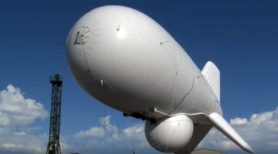
Besides land-based technologies, the real pig-in-the-poke that creates the illusion of Satellite utility are Light-Than-Air-Vehicles (LAV), High Altitude Airships (HAA) and High Altitude Platforms (HAP).
This updated concept of a proven technology takes lighter-than-air vehicles into a realm that gives users capabilities on par with satellites at a fraction of the cost (1 to 2 orders of magnitude less). The HAA will also integrate reconfigurable, multi-mission payload suites. HAA is significantly less costly to deploy and operate than other airborne platforms, and supports critical missions for defense, homeland security, and other civil applications. Its operational persistence eliminates the need for in-theater logistic support. In position, an airship would survey a 600-mile diameter area and millions of cubic miles of airspace.
-Lockheed Martin
Lockheed Martin has built more than 8,000 lighter-than-air platforms which is a pretty significant number for that fact alone. They also have a nifty brochure about LTA’s. Lighter Than Air Brochure

LTA’s are said to reach altitudes of 70,000 ft, but 100,000 ft and higher have been attained. They can stay aloft for months if not years, unmanned and controlled by ground based operators akin to drones. LTA’s also have the capability to maintain a geosynchronous position that satellites purport to do also. With the massive amount of money that NASA embezzles you can bet they’ve poured significant resources into developing these platforms. The more cost-efficient platforms, the bigger the profit margins are in NASA’s fake satellite deployments. It’s also important to remember that without the illusion of satellites and probes, NASA could not pretend to venture into the void of space to explore and reveal the wonders of the cosmos.
Here are some examples of LTA’s


HAA’s, LTA’s and HAP’s can take all shapes and certainly can be mis-perceived as satellites by the public. Besides High Altitude Airshsips there are HALE (High Altitude Long Endurance) stations or SPR (Stratospheric Platform Radios). As you can see from the list below there’s alot going on right above our noses. But the real beauty of the deception is hidden in plain sight. If we happen to spot various airships in the sky (even the Goodyear Blimp) we only know them as blimps, no big deal. In reality they can be providing all the capabilities that satellites allegedly provide and we’ve had no idea it was a trojan horse. Below are more proofs that the skies are more than likely crawling with these platforms.
High Altitude Long Endurance (HALE)


Stratospheric Platform Radios


HALO
High Altitude Long Operation (HALO) is the name of network based on the piloted Proteus airplane (mentioned earlier). 11 The pilots will assure a continuous service in three eight hours shifts using two or more aircrafts. The transmission capacity of a single platform, initially of 10 Gbps, can grow up to 100 Gbps and beyond, serving the coverage area of 100 km diameter by more than 100 separate antenna beams. Consumers will be offered access to video, data and Internet at rates of 1…5 Mbps. A broadband radio link at 52 Mbps has been demonstrated in 1998. 12
Sky Station
Sky Station is the name of a solar-powered aerostatic HAP system planned by Sky Station International.13 Initially, ion engines were envisaged. A single platform will provide mobile and fixed telecommunication services to an area of 150…1000 km diameter using spot-bam antennas. The planned data rates are 2 Mbps uplink and 10 Mbps downlink in fixed services. For mobile applications, 16 kbps for voice and 384 for data are planned. The cost of a worldwide broadband infrastructure is estimated at $2.5 billion.
StratSat
StratSat is a solar-powered aerostatic HAP system planned by Advanced Technology Group for civilian and military applications.14 When needed, the platform can be dispatched at distances of thousands of kilometres, from one region to another, and kept operational up to five years in the stratosphere. The platform could be kept quasi-stationary within a 1 km cube. The cost of calls from a mobile phone is expected to be an order of magnitude lower compared to satellite phone calls.
ARC
The Airborne Relay Communication (ARC) system is an aerostatic platform planned by Platforms Wireless International.15 It is designed to operate at sub-stratospheric altitudes of 3…10 km. Originally, it was designed for defence radar uses. Its communication version is to provide fixed and mobile broadband services to areas of 55 … 225 km diameter, servicing up to 1.5 million subscribers.
SkyTower
SkyTower is a solar-powered radio-controlled aerodyne platform planned by SkyTower Telecommunications.16 It is based on Helios airplane (mentioned earlier). The interactive network systems are being designed for the total throughput of 10…20 Gbps per platform (125 Mbps per user), with an average transmission speed of 1.5 Mbps. The company claims that the system, applied to solve the last-mile problem, will have over 1000 times the broadband local access capacity of a satellite (as measured in bit-per-second- per-square kilometre), a fraction of the cost of cable and DSL to deploy (as measured in dollars-per-subscriber) and to be capable of set up in days. In June-July 2002, the first HDTV and IMT-2000 transmission capabilities were successfully demonstrated, including video telephony using an off-the shelf handsets and Internet wireless modem at a speed of 384 kbps.
HeliPlat
HeliPlat is the name of an unmanned solar-powered stratospheric platform developed in the framework of a European project. Its applications cover localisation, environmental monitoring and broadband communications. The project involves some ten partners from Italy, Spain, United Kingdom, Slovenia, Hungary, and Switzerland. A number of interconnected HeliPlats will create a HeliNet, offering broadband fixed wireless access (BFWA) or local multipoint distribution services (LMDS). The services can include Internet, Intranet, e-mail, telephony, data, LAN, videoconferencing, video-on-demand, TV broadcast, etc. Burst data rates can be as high as 155 Mbps. The present design foresees up to about 120 cells, each served by a single horn antenna.17
Japanese HAPS
The Japanese project aims at an aerostat platform that will offer classic mobile, fixed, and broadcasting services and new terrestrial wireless interactive multimedia applications. Include will be multimedia mobile access (mobile handsets, personal mobile terminals), emergency access, business access, car access, ITS, train access, air access, maritime access, etc. The concept embraces relaying of digital television, direct newsgathering, local broadcasting, and many other applications. A network of five HAPS will cover almost the total Japanese territory with signal of arrival elevation angle above 5 degrees. For 10 degrees elevation angle, 16 stations will be needed. A similar UK project foresees six HAPS to cover the whole United Kingdom.18
Smaller specialized companies like ILC Dover work with NASA and DARPA on various platforms and support their development.
ILC Dover has been involved in the design and development of high-altitude airships since the early 1980s supporting development programs for the Navy and NASA. The subsequent growth of the cellular phone market generated renewed interest in the use of high-altitude airships as a means of providing economical coverage in developing countries. ILC has supported Lockheed Martin in the development of HAA vehicles including HALE-D (High Altitude Long Endurance Demonstrator). We are also supporting DARPA’s ISIS (Integrated Sensor is Structure) high altitude program.

Also companies like Near Space Corporation have other technologies such as (HASS) High Altitude Shuttle Systems, (SBS) Small Balloon Systems and (NBS) Nano Balloon Systems. HASS can reach altitudes of 100,000 ft and carry the HASS Shuttle as a payload.

If that’s not enough to cast doubt on the existence of satellites check out Project Loon by Google. Their motto is “Balloon Powered Internet For Everyone”
“Project Loon balloons float in the stratosphere, twice as high as airplanes and the weather. In the stratosphere, there are many layers of wind, and each layer of wind varies in direction and speed. Loon balloons go where they’re needed by rising or descending into a layer of wind blowing in the desired direction of travel. By partnering with Telecommunications companies to share cellular spectrum we’ve enabled people to connect to the balloon network directly from their phones and other LTE-enabled devices. The signal is then passed across the balloon network and back down to the global Internet on Earth,”

Four basic facts that NASA can’t or won’t explain.
1. How Do Satellites Survive 4,000F + Degree Heat in Space? There are only seven elements on the periodic table that could withstand this heat and none have been used for satellites. Satellites allegedly mainly reside in the thermosphere where temperatures can soar to 4,000F + Degrees. Not plausible

2. Estimates seem to vary on the number of satellites in supposed orbit. The latest number to date is 1265 functioning satellites with as many as 370,000 pieces of space-junk whizzing around at speeds of up to 22,000 mph. Click Here for the latest database of supposed satellites. This article in the Daily Mail had three points listed below. I find it odd that they report 22,000 objects can travel up to 22,000 mph. The odds those numbers are identical by chance is as likely as the sun being exactly 400 times larger and 400 times farther away to create the illusion it’s the identical size of the moon. 22 is considered an occult signature event number. Not Plausible.
- [*]
There are around 22,000 objects in orbit that are big enough to track
- [*]
Many are ‘space junk’ such as old rockets and abandoned satellites
- [*]
It is estimated as many as 370,000 pieces of space junk are floating in Earth’s orbit, travelling at speeds of up to 22,000 mph
A German photographer, Michael Najjar, has created the below image to show just how serious a problem space debris has become.

The image above by German photographer Michael Najjar for the article allegedly shows the massive space junk problem. How was this picture taken and from what satellite? Obviously this CGI/Photoshop/Pixar image looks like it was done with an Etch-A-Sketch. Not Plausible
3. No “Real Pictures or Video” exists proving satellites are whizzing around the globe, not one! Think how preposterous it is that one of the other 1,264 satellites couldn’t snap a simple picture or shoot a few frames of video? We have no visual evidence of actual satellites, the only evidence offered are sophomoric Photoshop/CGI/ Pixar images. Space.com has posted How To Spot Satellites but conversely Universe Today says
“If we could see these satellites from Earth’s surface, they would appear to hang motionless in the sky. The fact that they remain over the geographic same area means they provide the perfect platform for telecommunications, broadcast or weather observations”
So which is it, can you see them or not? I never have. I now understand how extremely difficult it must be to take actual photos of other satellites and earth simply because Satellites do not exist!! Not plausible
4. If the Van Allen Belts are so lethal (1,000 km to 60,000 km)
1. Land-based technologies. Loran (long range navigation)
2. GPS uses Cel-tower triangulation not Satellites
3. High Altitude Airships (HAA)
4. High Altitude Platforms (HAP)
5. Lighter-than-air vehicles (LAV)
6. High Altitude Long Endurance (HALE)
7. High Altitude Long Operation (HALO)
8. StratSat
9. Airborne Relay Communication (ARC)
10. HeliPlat which connects to the HeliNet System
11. High Altitude Shuttle System (HASS)
12. Small Balloon Systems (SBS)
13. Nano Balloon Systems (NBS)
14. Google Loon System
15. Stratospheric Platform Systems (SPS)
16. High Altitude Long Endurance Demonstrator (HALE-D)
17 Undersea Cable
18. DARPA Integrated Sensor is Structure or ISIS
So as you see there are at least 18 platforms that can be used independently, in tandem or groups to provide all the services that satellites provide. The most glaring aspect of satellite fakery is cost. All 18 platforms I’ve mentioned are substantially more cost-efficient than satellites and inherently more reliable. It makes no sense to continually risk hurling satellites into space if more cost-efficient, reliable and readily maintainable terrestrial systems already exist, which they do. Based on the previous five frauds revealed in part 1, the dubious existence of satellites is even more definitive since NASA cannot furnish a single actual photo or video footage of real satellites.
Which is more probable. That satellites exist but NASA seems incapable of confirming their existence or simply they do not exist at all? Occam’s Razor makes it simple, they don’t exist at all!!
Breaking News!!
Pentagon spy blimp breaks free, floats menacingly over US East Coast
Published time: 28 Oct, 2015 19:05
Edited time: 29 Oct, 2015 19:04
The US military is scrambling to recover an expensive spy blimp that broke loose from its moorings and is threatening air traffic north of Baltimore, Maryland. Fighter jets are shadowing the helium-filled balloon as it drifts over Pennsylvania.
The article was carried on RT News with nary a wimper. Question, when was the last time you heard in the controlled major mass media about “Spy Satellites” Answer, almost never or none. This was confirmation that high platform communications and surveillance technology has been deployed on a large scale. At 100,000 ft try finding a white or stealth designed 50-100ft blimp. That would be like trying to find a nano-particle in a bowl of soup. With cloud and geoengineering cover obscuring more they’re essentially invisible. Continue Reading

TARS, which stands for “Tethered Aerostat Systems,” utilizes radar equipped dirigibles in order to detect low-flying aircraft ostensibly seeking to evade the US air radar net along Mexico’s border. The system originally provided high resolution radar coverage over the US border while extending its range into Mexico, the Florida straits, and even a section of the Caribbean Sea, while also providing drug-trafficking surveillance for the US DOD counter-drug programs. In addition, TARS was considered a segment of protection for the North American Aerospace Defense Command with regard to their air sovereignty missions for the continental US.
The TARS dirigible
The discontinued TARS anti-incursion program was designed to be extraordinarily low-cost and had been in service since the early 1980’s, run largely by private contractors under government supervision. Despite increasing concerns over terrorists’ ability to use the porous border as a means to create havoc, especially in the air, the TARS program was said to have been of low priority, too expensive at about $ 3.5 million, and even technologically irrelevant in the modern day, which were all reasons being offered in 2013, for the program’s discontinuance.
TARS to JLENS
The newly announced three year test, which is being run by the US military, will tether a starting team of two dirigibles, set at an altitude of about 10,000 feet, over the Aberdeen proving Ground, which is an Army base located in Maryland. JLENS, visually, a startling similar platform as compared to TARS, except at about $2.5 billion dollars more The base is only about 45 miles north of Washington DC. The stated goal of these dirigibles will be to detect cruise missiles launched from somewhere off the East Coast, a long-held problem apparently, which is only now being unveiled as a valid concern, at least in some upper-level circles.
However, many believe the updated program which will be identified under the acronym JLENS (Joint Land Attack Cruise Missile Defense Elevated Netted Sensor System) may have another use altogether, which centers on extraordinarily unique surveillance capabilities centered along one of the most populous corridors in the entire US.
These same aerostat systems were used to great effect over both Iraq and Afghanistan while using state of the art surveillance systems powerful enough to detect movements of both insurgents and US soldiers, individually.
A Higher Perch
Despite the Army’s recent statements of “no plans” for surveillance cameras, the system has already been touted as having the ability to detect and radar track cars, trains, and even boats, however, the system has been stated to have no actual capability of tracking individuals, despite the use of the word LENS being omnipresent within the acronym.
Experts offering a defense of the program, indicate that the high angle of view for these types of heightened surveillance systems severely limit such system’s capability to detect a face or a license plate. This despite the fact that a JLENS system over Kandahar positively identified the images of recently convicted Sgt. Robert Bales, returning to his base during the night after murdering numerous Afghan civilians in their sleep.
The dirigible, long a mainstay of dystopian science fiction novels, may become a permanent part of the US urban skyscape, at least if government designs are maintained. Indeed, the other questions of such surveillance systems over the US, center on the extraordinary abuses still being discovered concerning NSA eavesdropping on US citizens, and drones being used to strike civilians. In March of 2013, Conservative Sen. Rand Paul, supported by the ACLU and other Liberal groups, instituted a US Senate filibuster designed to force the Obama Regime and Attorney General Eric Holder, to answer the question of whether or not drones might be used by the US government to strike US citizens.
The US military, under direction by the White House, has plans for at least 16 surveillance systems such as the one being test deployed over the nation’s capital. However, the possibility of an aerostat system theoretically being used to direct drone strikes can’t be dismissed, as the US continually seems to be more and more directing its security systems inward towards its own civilians, while previously stating that the same system along the US-Mexico border was both too expensive and largely outmoded by modern technology.
Strategically, while the US East coast might be construed as vulnerable to cruise missile attacks, the JLENS system’s first deployment might beg the question of why the East Coast? The US Pacific Coast appears far more vulnerable to attack by certain increasingly hostile Pacific powers, which are significantly more likely to use the Pacific Ocean as an attack approach to the US, rather than the Atlantic.
The JLENS development cost, currently pegged at $2.7 Billion for 2 systems, is far higher than the discontinued TARS program with its cost of about $ 3.5 million annually, despite being described as using essentially the same technology. (source)
The Occult Roots Of NASA And The Ongoing Fraud: Part 3: Space Does Not Exist!
See Related:
How Do Satellites Survive 4,000F + Degree Heat in Space?
Did We Go to the Moon? The Van Allen Belt Mystery
How Can NASA Measure Stars a Hundred Million Quadrillion Miles Away?
How Did Apollo Moonwalkers Survive 200 F + Temps?
How Did Gemini and Apollo Crews Not Break Their Backs on Splashdown?


Great I depth research!…. I new they were rubbish when I fitted a sky dish to my house…the cable used for the satellite dish is identical to the freeview aerial and shares the same amp ? I could not get it aligned so payed a local sky engineer £20 to align her took him a few seconds with his digital signal finder told me it was aligned with said sat…after he’d gone I found it funny it was pointing in exactly the same direction as my freesat Arial ? To the big mast on top of the hill….in other words land based and even the angle these dishes are not exactly pointing up into space !
LikeLike
Hi,
Indian Space Research Organisation ISRO has launched several satellites. It has also successfully launched the Mars Orbiter Mission, which has sent several pictures of Mars and of earth as well, please see the link
http://www.isro.gov.in/pslv-c25-mars-orbiter-mission/pictures-mars-colour-camera-mcc-onboard-india%E2%80%99s-mars-orbiter
In May it is going to launch 22 satellites on one rocket
http://www.thehindu.com/sci-tech/isro-set-to-launch-22-satellites-on-one-rocket/article8406533.ece
Thanks
Ashley
LikeLike
RSA, India, China Space Agencies all coordinated out of NASA
LikeLike
I’m sorry, but none of the videos you pointed to show that RSA, India and China Space Agencies are coordinated by NASA. Do you have any evidence to back up your assertion?
LikeLike
This is another issue I have. We are on satellite internet and have no direct line of site broadband available without a 80 to 100 foot tower, yet we have good cell signal from one cell phone company. We are in the northern “hemisphere”, so I haven’t yet determined if that is a factor for certain, but it certainly looks like the number of satellites is -at least- greatly exaggerated. GPS failing to do what it is supposed to do at the southern hemisphere is certainly a major issue.
At any rate, I greatly appreciate the work on this. I wonder why satellite has to limit the bandwidth for internet, yet tv just pours right in with no limit???? Hmmm.
LikeLike
Remember, they only give us their old technology. My research is showing they set up the base Over the Horizon radar around the Antarctic Circle back in the early 60’s, late 50’s.
Look at the way satellite dishes face, only about 30 degrees up…why? if the satellites are hundred and fifty miles up and traveling in “geo-sychronous’ orbit. The dish should be pointing nearly vertical, right?
Why do we lose connections if the satellite is so high above us? makes sense though if it is Over the Horizon.
So many questions. thanx for all your contributions here.
LikeLike
Hi there jwlpeace.
Late to this party, I know. Nevertheless… There are so many incorrect details in this story and comments that deserve responses, but one thing I have to correct. “Geo-stationary” or “Geo-Synchronous” satellites are not stationary. They are purposely launched and positioned at exactly the height that results in an orbital speed that is exactly the same as the Earth’s speed of rotation – i.e. once per Earth day. Of course, they have to orbit in the same direction as the Earth’s rotation as well… Thus, when launched, positioned and kept in position by infrequent, controlled maneuvering rocket bursts, they appear to be static. To most observers on the ground, they do not appear to move. Thus, they can’t really be distinguished from stars, except when they pass into or out of the Earth’s shadow. Naturally, in the shadow, they are very difficult to see.
Now, what is not perhaps so obvious is that there is only one latitude and track that is usable for geo-stat satellites – directly over the equator. Put it anywhere else and it will naturally swing north and south of the equatorial point, making it useless for reception by fixed satellite dishes.
So, in order to pick up a geo-stat satellite signal, your dish has to point to a spot in the sky, directly over the equator. If you happen to live on the equator, your dish will also align along the equator, but unless your satellite is directly overhead, it will still be at some angle below vertical. If you live at a higher latitude, such as in the UK, the dish will be pointing in a southerly direction, at maybe about 30 degrees above the horizon. The further north you go, the lower the angle until you cannot ‘see’ the satellite at all.
Hope that’s some help.
LikeLike
“I wonder why satellite has to limit the bandwidth for internet, yet tv just pours right in with no limit????”
It’s really simple, truthfarmer. The satellite is a single box, pretty far away – and very expensive to get it there. Contrast that with the local phone or cable office, where they can pretty much add capacity at will, and at much lower cost.
The satellite dish is not pointed straight up because the satellite is positioned to cover a large area, like the entire USA, so it’s unlikely to be directly over your location. Just because they are in geosynchronous orbit does not mean they are directly above *you*.
LikeLiked by 1 person
Hey history, I mean satellite tv and satellite internet. I’ve heard all the explanations from the companies for the internet limitations. I contend it is creating a commodity beyond logic. The signal streams to the tria and isn’t encumbered by the number of customers…They are always trying to get more customers.
Around here, they have to point the dishes to the southern sky, and the sats are supposed to be geosynchronous. And generally it works pretty well. I know some people that actually own a satellite tv franchise and am somewhat familiar with the mechanics of lining up the tria to the signal being sent. It’s pretty tight as far as focus to receive the signal from the particular company.
And I can understand how they need to be paid for the service, and I am not against that, just would like it to be actually usable in the paradigm. So much is video any more and it is difficult to research things beyond written documents any longer with limited bandwidth. So I whine. 🙂
LikeLike
Just finished actually reading the entire post. My comment is now amended to holy crap.
So, if I am properly understanding, the only reason to “limit the bandwidth” is to price the paupers out of the nether regions. For instance, when you don’t have high speed internet outside of satellite available, it costs a minimum of $60 to get it with limited bandwidth. $140 if you want it to be “virtually” unlimited. Then, due to monopolies that aren’t supposed to exist in reality, if you have a land line, it’s about $75 with basic current paradigm requirements. Then, since everyone (understandably) wants to text, you have to have an additional expense of about $55 per month for cell phone. Not including the phone, of course. So, clearly, as per Agenda 21 and the more strident Agenda 2030, the obvious desire is to move people into cities where “everything” is soooo much more “affordable”, except for real food and air and the chance at living in harmony with the creation instead of the controllers. People who know how to live and to help others live off the land and the real economic reality of “we all have to eat to live” are undesirable and to be eliminated slowly and steadily as since 1953 via the OEC edict to farmers “get big or get out”.
So this lie, of a globe and space and satellites, works in concert with all the other things that Yahweh calls abominations (unjust weights and measures-our entire economic system) to put people in a position of being easily controlled and easily starved into complete control.
Check.
LikeLike
Yea, and they’ve been working our minds professionally for centuries but with modern technology they can OWN our minds (minding?)…see this, if you haven’t already. They are near total control of humanity, truth be told.
Each and every year for decades Billions and Billions have been spent studying one area between the ears and behind the eyes, what do you think they have learned about behavior modification techniques…it goes way beyond bandwith TF. Way beyond.
LikeLike
Thanks, I will have to download it in our “free zone” and watch it in chunks because it is three hours long. Looking forward to it though!
I’m not a newbie to the control paradigm, but I do contend that there isn’t really a way for one person to solidly comprehend all the mechanisms and measures working in concert, although there are effective foils that overlay virtually all these implementation methods. My predominant focus for more than a decade has been in the food freedom and real food arena.
About five years ago when I had my own radio show I did a program regarding the (at the time) virtually unknown issue of adding nano particles as flavor enhancers and preservatives to food. At that time, there was only one study on the effects of these items on mice, and the results of that study were not good in any way. Yet, of course, the Food Destruction Agency said they were just fine for us. No knowledge or consent necessary to be part of a medical trial if you live in this country. Numerous affronts like this are evident to those desiring to look…
Then I thought I would dig into “mind control” because it was shortly after all TV went digital because they claimed we were running out of air to send signals through due to the proliferation of cell phones. LOL. Turns out, it is a UN initiative and every member nation had to put in the legal framework required for digital television. In the US, that passed as part of the 2002 Farm Bill.
Then, there is the very easy to install neurolinguistic programming that cannot even be detected by any instrumentation, into any digital media. So you could record something, and after that, someone could implant programming without your knowledge and that implant would effectively replicate every time someone copied the digital media. Again, no need for your knowledge or consent.
Additionally, the research led me to two groups that work in concert on shaping the public opinion to the desires of those who seek power and control over others for their own enjoyment or increase. Those groups are Tavistock and the Aspen Institutes. Tavistock works a bit more in the algorithm methodologies and Aspen works more on social management via media, ie. political correctness and “don’t be a hater” idioms.
Now, before anyone jumps in here and tells me to put on my tin foil hat, you need to check into what I have asserted. I have nothing to gain from any of these assertions and I have a continual working stricture that I abide by completely.That being: “There is no need to make anything up because the truth is bad enough as it is.” The only thing I want is for my children to have a chance to live and work and profit from their labor if their efforts are good and honest. I want them to succeed or fail on their own merits in a relatively free environment. That is my “benefit” from striving to find the truth in all matters of importance. Incidentally, I want the same for other people’s children.
Now that we are (seemingly) waaaay off of satellites, I’ll hush up and see if others have any thing to say.
LikeLike
Tavistock and Aspen are underlings to the main power source, The J-E-S-U-I-T-S. The Information is overwhelming in in its prima face evidence and fact.
Here is some more of Tavistock’s handiwork to mass mind control
Theodor W. Adorno; Songwriter for All Beatles Songs; Director of Frankfurt/Tavistock Social Engineering School
And a list of just many of the Secret Societies no one has ever heard of but many have existed for centuries.
Take the Test #1. How Many Secret Societies Can YOU Name?
(also vid/doc above is broken down into ch.’s in the show notes.)
LikeLike
Just been given this link by a subscriber to my channel…thanks to those involved setting this channel up…: ) looks like a lot of good info….. kj..
LikeLike
This website is a remarkable source of information. Glad to have found it a few months ago.
I would say that the hardest notion to embrace out of this entire web of deception is the “silence” of virtually all space programs and agencies throughout the world; a total of 70(involving thousands of scientists) , and 13 with launch capability. If anyone has any insights I would appreciate it. Thank you
LikeLike
Where were plenty expeditions to the Antarctica, why do you say where were none? Or all the expeditions during last 200 years were done by the the guys who are into conspiracy as well?
LikeLike
I have just spent the last few years travelling around Australia. I’ts a popular pastime here for retirees in their thousands. Australia is a huge continent and much of it is unpopulated and remote. Cell coverage is spotty, mostly available in population centres around the coast, major inland towns and along some major connecting highways. Everywhere else, which is the majority of the land mass, too bad – no mobile phone or internet coverage for you. TV is the same. Transmitters cover population centres and everywhere else misses out – or at least they did until satellite technology came along. Now anybody living in remote areas or travelling in the middle of nowhere can have free TV and even pay services like Foxtel. It is common for people travelling about with caravans to carry their own satellite dishes and receivers. I have one. Probably the majority of what we call the “grey nomads” (retirees on endless travels to their favourite outback tourist or fishing spots) have one. No-one wants to miss their favourite TV shows ever in the middle of the Outback. We have one satellite that everybody uses. It’s stationary up off the north east of the continent. Doesn’t matter where we are in Australia, we have to point the dish at that satellite to get a signal – and the aim has to be spot on! At the furthest points from that satellite, in fact where I am now in the deep south of Western Australia, the angle of the dish to that satellite is really low. Conversely, when I was on the other side of the continent and about as close to the satellite I could get without driving into the Pacific off the North Queensland coast, I had to point that satellite dish almost vertical to get a signal. Even when the nearest cell tower was hundreds of kilometres away, we got free to air TV (via VAST service) and pay TV via Foxtel by locking on to that Optus satellite and tuning in the receivers. Also, finding a satellite when there is virtually no margin for error takes a bit of doing. I use a book that has all the telemetry information for the whole of Australia and an electronic thingy that measures signal strength etc for identifying and fine tuning the signal. So add that to what you know or don’t know about satellites.
LikeLiked by 1 person
I am truly conflicted on the Flat Earth and satellites issue. I have worked in the Satellite TV industry and the technology works as described on my courses, the dishes pointing at the sky. I conclude that there are some kind of satellites doing a job in the sky, but perhaps they are blimps etc. I’ve always found the geostationary logic to be somewhat dubious and quite implausible. My TV dish, although not pointing up high, must be in line with something thousands of feet in the air, but not miles up.
On the equator, TV dishes can be seen pointing up vertically, so this lends to the credibility of there being real satellites.
I just find the sweeping statement of satellite don’t exist too much to accept, yet I am convinced we’re not on a sphere…
LikeLike
If you really are conflicted, do yourself a favor and learn about logic, how to reason and the logical fallacies used to “prove” the bogus flat earth assertions. All of their supposed proofs are actually logical fallacies considered invalid by anyone capable of rational, logical thought.
https://yourlogicalfallacyis.com/poster
https://www.sophia.org/tutorials/logical-fallacies–2
LikeLike
This is excellent, I just ordered two
LikeLike
Right let’s talk facts vs logic. To be logical doesn’t automatically correlate to truth. Show evidence of earth curvature. You can’t. Every experiment to measure curvature shows there is none. Keep staring at your posters. The earth is Flat and and that is not going to change no matter how many posters you promote along with the endless false NASA pseudo science masquerading as fact.
LikeLike
good info to read.
Jules, our tv satellite dish here in equator area is facing 30-40 degree, not vertical…i never see any vertical dish in few countries around equator…
LikeLike
How is the angle the dish faces a factor for this topic?
LikeLike
Thank you so much for this information it is incredibly invaluable! I was recently having a discussion with someone who believed we have space satellites. I was trying to come up with a good argument such as high-altitude balloons when I ran across this article. With your information I won that argument. Keep up the good work! I also enjoyed watching your videos.
LikeLike
You give as a reason that “satellites can’t exist” the fact that near-earth satellites orbit in the thermosphere, where temperatures are very high. Yes they are, but it’s a near-vacuum – the gas is so thin that it can’t transfer any but tiny amounts of heat to objects in orbit, or rockets carrying humans into orbit or to the moon.
Communication satellites,are in geosynchronous orbit around 25,000 miles out, more than 24,000 above the thermosphere.
Why no pics of satellites in orbit, taken from another satellite? Because if they were close enough for that, there’s a high risk of collision. No one would need such a photograph, it’s the same satellite that was launched into orbit, plenty of photos before that.
You can see satellites in orbit, on almost any clear night. It’s easy to look up satellite passes over your location. Many websites available for that. For example
https://in-the-sky.org/satpasses.php
Or is your head so deep in the sand you never look up?
I just read a comment from a muppet who claims there were almost no trees before 200 years ago. Reasoning? Most trees are less than 200 years old, which is true. No wooden houses, no firewood, no fishing boats, no Spanish Galleons before that then?
Try this: Most humans on Earth are less than 100 years old – fact. Therefore, more than 100 years ago there were almost no humans on Earth? George Washington had nothing to fear from the British then, they could’t have existed!
The problem with conspiracy theorists who push crazy ideas like this is that they know no basic physics or history at all, and believe just what they want to, which of course comes from magazines and websites written by other conspiracy theorists. Entirely closed thinking.
LikeLike
Tony? Do you believe the moon landings happened? Do you believe the issue exists with human beings on board?
LikeLike
It’s not a question of belief, but fact.
LikeLike
“You give as a reason that “satellites can’t exist” the fact that near-earth satellites orbit in the thermosphere, where temperatures are very high. Yes they are, but it’s a near-vacuum – the gas is so thin that it can’t transfer any but tiny amounts of heat to objects in orbit, or rockets carrying humans into orbit or to the moon.”
HAHAHAHAHA
“Do you science bro ?!”
What is warming the thermoshpere ?
Is it at this very high temperature because of something ?
Maybe the sun ? no ?
Therefore everything in this thermosphere would have to suffer very high temperature at the same time.
Luv it, when people repeat without thinking the wikipedia non-sense.
LikeLike
How can we see a tiny satellite that is 25000 miles away? The size of these satellites would mean they would not be visible on a desert plain 10 miles away( not allowing for curvature of course!!!!)! Please explain where and how all the hundreds, if not thousands of satellites, that supposedly orbit the earth are space traffic controlled and they are never photographed or seen from the ISS? I know why they are not seen from the ISS but will be interested in any answers!! How are they maintained as no one can or has ever travelled 25000 miles into space. How did they achieve these distant orbits? How do they maintain their orbits as the magical gravity would be trying to pull them back 24/7? Perhaps they must ‘ebb’ and ‘flow’ as the moon supposedly pulls on our oceans and these are nothing compared to countless trillions of tons of water. Just want some simple, reasoned, factual, provable answers.
LikeLike
“How can we see a tiny satellite that is 25000 miles away?”
Easy, just use your telescope and camera. You just need to know where to point it. Geosynchronous stallites are visible near celestial equator (CE). On north hemisphere slightly north from CE, on south hemi slightly south from CE and on Earth´s equator right on CE. It´s because of your topocentric position on Earth globe. These satellites stand still on one point of sky, so you have to make long exposure with stopped telescope mount. Then you can make photograph of still stalellite(s) with background of moving stars (due of Earth´s rotation).
Many other satellites are much lower and them you can see pasing sky during night, because they reflect sunlight. Summer is better for satellite observation than winter, because Sun is not too low below horizon and even lower orbits above your head are lit by sunlight. But you have to know that not every satellite reflect enough light to be seen by naked eye.
Satellites are mostlly non maintenance devices. It should sound strange to you, but it is easier and cheaper to send up new one instead of maintaining or repairing old one or broken one. There is maintenance almost only for space stations like ISS or like was MIR. Some peoples travel even farther. About twenty astronauts were on close orbit of Moon and twelve of them even land on it´s surface. But there is no spaceship designed to make maintenance on geosynchronnous orbit. Some maintenance was done on low Earth orbit during missions of Space Shuttle. I´m quite sure that there are some experiments with small inspection satellites for geosynchronous orbit, but I´m not sure if they are operational already.
“How did they achieve these distant orbits? How do they maintain their orbits as the magical gravity would be trying to pull them back 24/7?”
Distant or closer orbit, always the same way. It´s all about deltaV (not that rocket, but change of velocity). You have to reach some (high) velocity to orbit around Earth. It´s called First cosmic speed (FCS). At low orbit It´s about 8 km/s. At higher orbits value of FCS falling. Moon orbiting around Earth have almost FCS (Moon orbits slightly faster and because it have not circular but slightly elliptical orbit), but in distance of 380 000 km from Earth (at that height) his orbital velocity is only about 1 km/s.
Generally: When you want go higher, you have to raise your velocity. Circular orbit then transform to elliptical. And with rising velocity the ellipse becoming more and more eccentric. When farther end of ellipse (apogeum) reaches infinity, orbital shape changing from elliptical to parabolic and you reached Seccond cosmic speed (SCS). That speed means that you can fly out ot from Earth (out from its sphere of influence). For Earth is SCS from low orbit about 12 km/s.
You also have to mind, that velocity during orbits isn´t constant, but vary in some range, because velocyty rely with kinetic energy of satellite. But with changing of distance from center of mass of Earth (changing altitude) cause changing of ratio of kinetic and potential energy of satellite. (Close to planet – high kinetic and low potential, farther from planet – low kinetic and high potential energy).
Andy why all this? That´s because gravity is´t “magical”, It´s just general centripetal force which must be in this case negated by some other force with opposite direction and that is centrifugal force. You know it, that is force which always trying to push you out from car seat if you driving on curved road. If you moving by FCS, centripetal and centrifugal force are the same, but with opposite directions and don´t affect your movement.
“Perhaps they must ‘ebb’ and ‘flow’ as the moon supposedly pulls on our oceans and these are nothing compared to countless trillions of tons of water.”
These pulls affect everything on Earth, even you. They affect height of atmosphere, They affect height of continents (like oceans, they rising and falling for some centimeters (cca 20 – 50 cm or 8 – 20 inches if i remember it correctly). So they affect even satellites, but not much. Active satellites have small thrusters for menauvering and small orbital corrections. Innactive staellites and space debris changes it´s orbits slightly. That´s why they are still watched by special telescopes and radar stations, to protect these still functional satellites, and humans on space station.
Tidal effect from Moon isn´t only one or strongest source of orbital changing. On low orbit it´s friction of upper atmosphere. On high altitudes it´s even such thing like pressure of light radiation. But all these effect are well known and satellites are designed to deal with them.
Sorry for my english, it´s not my native language. Unfortunately I´m unable to say it shortly and simple, but I tried to answer you reasonably and factual right. Of course that complete explanation woud be more complex and I dont know what all you know and what have to be explained.
I just have to say that this artice up there is realy big pile of bullshit. Author make lots of argumetation fauls and don´t understand or don´t want to understand even a very simple and general laws of physics. On many places he simply telling lies. Yes, there is a thousands real images of satellites, look for examle there: https://www.youtube.com/watch?v=nsc80evqJ88
I doubt that he woud listen reasonable explanation even if I woud try to tell him 😦
LikeLike
How would you respond to comercial industries such as LORAL which has no affiliation with NASA or worked with them in years. As an engineer I understand what parts are what and understand how much they cost. Tell me then, why I take part in month long projects to put together a 300 million dollar puzzle and then watch on live feed(and once in person) the puzzle go to space? Perhaps we spend 300 million for specialized parts that are made to be dependable and survive extreme enviroments for nothing? Put the sattelite in a vacume sealed container and surround the container in liquid nitrogen to emmulate space for nothing? And ofcourse go behind schedual and take the sattelite appart when a test is failed? What are your qualifications because I doubt you could even name the commponents to a highschool class breadboard.
LikeLike
Oh, thats an easy question; a breadboard is a piece of wood and of course the bread knife for use in slicing. 🙂
LikeLike
Hello,This is a interesting article yes we do live on a flat plan for any body with eyes to see, Worlds beyond the poles on youtube and read the book off. The us navy made extensive studies back in the 1940 and 1950, they discovered land the size of the US beyond Antarctica.
LikeLike
Exactly what direction takes you “beyond” Antarctica?
BTW – As our eyes also tell us we are not made of atoms, that part of science is no longer valid. This leads to the inevitable conclusion that there are no electrons, so our communication on this matter is impossible.
All that thanks to our eyes.
LikeLike
Tom, it is very clear that what Admiral Byrd described as an area “beyond the south pole” meant, “beyond the south pole as you travel to it from South America.” Basically this is East Antarctica. If you look at a (non-flat Earth) map of Antarctica, you will see that it is a vast, at that time unexplored, area.
Of course this is impossible on a flat Earth – hence the speculation!
LikeLike
Tom – and like you, Tesla didn’t believe in electrons! Reckon all these ‘puters are BLACK MAGIC!
LikeLike
Mike,
I wasn’t aware that phrase was in anyway connected to Byrd, as nothing was mentioned by Steve. Minor point – the quote is “beyond Antarctica”. not the south pole. 🙂
To be clear on my “atoms” comment; I wasn’t offering my understanding of the subject, but was using what Steve said about needing to “see” things with understanding. A weak parody, at best.
I actually work directly with computer systems as a career, and fully understand their fundamentals on a variety of levels. 🙂
Thx.
LikeLike
Tom, I’m pretty sure Steve was referring to Byrd’s report, it comes up often from FE believers.
I got your parody in your comment on electrons – I failed to make my sarcasm clear enough!
LikeLike
I’m dumber having read this article.
LikeLiked by 1 person
no, admin is, i approved it!
have a lovely day.
LikeLike
So there are thousands of satellites which 1 manage to avoid collisions not only with each other but also with space junk meteor showers the heat from the sun ( a solid conductive object would absob heat ).Can also receive and transmit through radiation, strong magnetic fields and a plasma belt
And use rockets and thrusters that don’t comply with Newtons law 2 and 3 . ( they just blast away into an infinite vacuum ).Oh yeah you’ve convinced me and true science.
LikeLike
Maybe I’m off base here but it seems like one of your proofs is that there is other technology out there cheaper and better suited for the purposes of data transmission. Therefore, satellites can’t exist because we have better ways of accomplishing the task. Unfortunately, you can’t rationally make this claim.
By the same logic: we know all cruise ships are fake because air travel is far better at handling the task of transporting people. Thus, no one is making cruise ships anymore, and all claims of there existence are fake.
Makes sense right? NOT!
LikeLike
“Four basic facts that NASA can’t or won’t explain.
1 .How Do Satellites Survive 4,000F + Degree Heat in Space? ”
-This is a simple one. It’s called engineering. The satellite computers are DESIGNED to withstand temp fluctuations.
-Your computer might not be able to withstand the temps, but it wasn’t designed this way because it’s only needs to operate within a certain expected range. Satellite computers are “hardened” in their design to withstand severe temps.
Here’s more info: http://www.astrome.co/blogs/how-do-satellites-survive-hot-and-cold-orbit-environments/
Guess you are wrong, since there actually is an explanation. Must it come from NASA for some reason?
Your “proofs” just doesn’t make any sense to someone trained to think rationally using logic..
LikeLike
This article is total a school-grade bullshit. In short, it says “there are obvious 2 types of systems, passive/actice, we won’t tell anything about them, btw, we can use aluminium/heatpipes to distribute heat, but we won’t tell you where the heat goes either”.
Lots text about nothing. They also talk about RADIATORS, but, excuse me, WHERE DOES THE HEAT GO? There’s NO AIR to take the heat away!
LikeLike
[…] information is readily available if you just look! Links Used: IMDB Fake Satellites & NASA CGI Satellites Don’t Exist Human Pop. Growth & Climate Change Weather Modification Illegal Mining 500 Days Avoid Climate […]
LikeLike
If you believe there are no satellites and we nave walk on the moon then you are a stupid fool. I guess you believe the world is going to end soon, and Donald Trump is the president ever. I have witnessed several launches directly and to the point of live coverage of the departure WITH MY OWN EYES. What you think the space walk and everything else is a conspiracy? I guess your one of those that are a conspirator. With that being said, I guess opinions are like ass holes, every has one. the full truth is, we did walk on the moon, (and yes went right through the radiation because we have special suites and protections) and we h=did and still do launch satellites and how do I know all this? I am the top communication expert with the Military and we use special military satellites for all kinds of things. Know the truth before you post something like this, because it’s people like you that bring nations down with foolishness and untruth thoughts because you have a theory. What you are saying is nothing other then rubbish. Get a job, go to work and learn the truth about the world.
LikeLike
>>we have special suites
yeah, right 😀 book me one!
LikeLike
[…] A year and a half later, the images have not materialized (perhaps it’s because there is no such thing as “satellites”). […]
LikeLike
Wait happened modern gnostic.com?
LikeLike
Bruce Passed away in June. He is sorely missed.
LikeLike
to anyone who wants to argue science of satellites, stop. very simple way to prove satellites are BS- do your research- make a timeline, I suggest starting with gps and going back. then do same for submarine cables. then insert outages in gps and internet in comparison….. the in claims 99% of communication come from fiber optic cable. they have a 68 page report on how the only are on earth that needs satellite comm- Antarctica….. its a rabbit hole, but I guarantee you will find the truth if you care to hear it
LikeLike
Hi! I’ve been working for quite a long time in telecommunications. I also happened to work at a satellite lab (NOT in US). The reason for bandwidth limitations are simple: you have, for example, 80MBps total capacity sliced into N channels resulting in each channel having very thin width. Minimum channel bandwidth is determined by amount of data required for SAT TV. TV data is a simplex broadcast signal (one-way), and is easier and cheaper to provide. TRUE duplex satellite internet requires quite powerful and expensive equipment.
But closer to the point… Open a good old more or less specialized radio learning book and learn about signal reflection from ionosphere. Don’t you find it a little strange that radio waves reflect from something non-metallic back to the ground?
There’s also one thing that practically bothered me: as far as I remember, water absorbs waves around 2.4GHz, but somehow TV reception (which showed aroud 10GHz) was getting much worse during rain.
LikeLike
how come you guys can agree on a flat earth map, or even whether or not Australia exists?
LikeLike
Earth is an OBLATE rotating spheroid. Oblate means flattened at the poles.
LikeLike
Because you say so? You’d better go tell go ogle earth. Better yet, where is that earth cam? 😆
LikeLike
The eminent NASA stooge Mr deGrasse Tyson is on record as saying that the earth is also not just an “oblate spheroid” but rather that it is “pear-shaped”!
But what boggles my brain is how men like the afore mentioned make such statements when they know fine and well that NASA have churned out countless images depicting a perfectly globe shaped earth!
Do they all think we all live in cloud cuckoo land, as indeed they do?
I am sure that this video is on this comprehensive site somewhere, but here it is anyway.
LikeLike
Orbits as depicted cannot exist. Think! After 1 round, the ISS has been submitted to the acceleration of gravity, about 9 m/s/s, and will be falling vertically, meaning TOWARDS the earth with a speed of 3600 x 9 m/s. Roughly 3.2 km/h.
LikeLike
3.2 km/s of course…
LikeLike
Jan,
I suggest you research the definition of orbit, and restate your opinion. 🙂
A few facts might also be helpful.
LikeLike
OK, I admit that my post was sloppy. Very sloppy…
Let me try again.
The definition of orbit as meant in my post above:
The curved path of a celestial object or spacecraft round a star, planet, or moon, especially a periodic elliptical revolution.
The periodic elliptical revolution implies that the object returns to its exact initial point after each revolution.
If we take the International Space Station as an example of the above mentioned celestial body, we can look up the next values on the internet:
Altitude: 400 km
Orbital speed: 27600 km/h = 7,6 km/s
Gravitational attraction at 400 km altitude: 8,7 m/s²
Duration of one orbital revolution: 90 minutes
The ISS is said to be in what science considers to be a continuous fall towards the earth. The specialists tell us the next story: Gravity pulls the ISS towards the earth, inertia resulting in a centrifugal force pushes the ISS away from the earth. If the orbital speed has just the right value, inward and outward forces annihilate each other.
But I object:
After one revolution gravity has acted during a period of 90 minutes upon the object resulting in an increase of its downward (=towards the earth) speed of 8,7 * 90 * 60 = 46980 m/s = 47 km/s.
My conclusion, or better, the conclusion of my cute little computer program SATORB: ISS can only fly for 842 seconds before it hits the ocean, a mountain or something alike.
The whole goddamn population of the earth seems to be totally blind to logic when it comes to judging specialist reasoning. And the heretic amateur who dares to think for himself and open his mouth is laughed away.
LikeLike
A screen copy of SATORB.
LikeLike
Jan,
Thanks for the additional details; they support independent review and verification.
Most of your numbers seem to be correct, except for the ISS radius (I think). Based on a comparable take on this exact scenario here (http://www.softschools.com/formulas/physics/orbital_velocity_formula/76/), It seems you left out the earth’s radius in the ISS altitude factor. At 4000 km above the earth. the gravitioal force is reduced as discribed here (https://www.sciencelearn.org.nz/resources/268-gravity-and-satellite-motion).
The calculations at the 1st link above confirm that the ISS is still safely in orbit, based on the raw data values you supplied (and they confirmed).:)
LikeLike
@factyouall
You got my data wrong. The ISS is not at an altitude of 4000 km but at 400 km.
As to the integration of the radius of the Earth: I did take it into account.
Which enabled me to easily calculate the gravitational pull at 400 km altitude namely:
9.8 x (6400^2)/6800^2
As to the discussion whether gravity exist or not: it doesn’t matter how precisely object are pulled by or pushed upon the earth. The result is that things tend to fall down and crash which is all that matters here.
LikeLike
Hi Jan,
The only part of being wrong was the label I used. The 4000km is not above the earth, but from the center of gravity, which accounts for the radius of the earth.
The first link I provided clearly shows this:
Answer: The orbital velocity depends on the distance from the center of mass of the Earth to the space station. This distance is the sum of the radius of the Earth and the distance from the space station to the surface:
r = (6.38 x 10⁶ m) + (400 km)
Sorry for the labeling error 😦
As to gravity, you make a good observation However, for others who claim density is what is happening, never provide any evidence why there should always be a preferred direction of down. Where are the scientific explanations why density has a favored (or any direction)?!!
LikeLike
Electromagnetism is the force. The earth has a static charge as does the atmosphere. That is what the attraction is. That is why things fall or sink on earth. Tesla had it figured. There is no core. We’ve never gone deep enough to know. We couldn’t even get down to 8 miles. So it’s all speculation and cartoons. If the earth were a globe, the directions of up and down would not be constant/consistent and are more aptly described as in and out based on the imaginary center.
LikeLike
poolman,
Thanks for the response. Are you able to choose between density and EM to explain falling, or does one of these cause the other, or have some tangible link?
FWIW, none of this new information agrees with the many density claims that have been made, so its easy to be skeptical of any “new” and radical claim.
As an aside, EM should be easy to measure, with any number of devices that can register such a phenomenon. Can we look forward to your evidence behind the claim?
LikeLike
I don’t understand where the 4000km comes from….
Radius Earth plus given altitude of the International Spooky Ship =6400+400=6800 km and not 4000 km
LikeLike
Jan,
You are correct, I had the 4000 km value for distance from ISS to earth center all wrong. At the same time, however, I did have the correct values in the equation I included. As I recall, your first (orbital) calculation relied on only 400 km altitude, which as we both know is not how the calculation is used.
Since you’ve corrected me (thanks!), I guess, in a way, you’ve also corrected yourself. That might also indicate you acknowledge making a mistake early on (these things can happen to well intentioned people). 🙂 Solidarity!
LikeLike
I just realize that this is a FE site. I should have known: the “plane truth” says it all. Personally I’m not a FEer, but I have friends who are and our friendship perfectly outlives our different view points.
LikeLiked by 1 person
If you aren’t there yet, give it time. I was a globe believer for 59 years and only in the last 2 have I seen this place through different eyes. It’s a flattish stationary plane. It’s testable and easily verified. The fact that water is totally flat and level when in a resting state gave it away to me. Of course I have been working with water for 43 years and it took actually seeing past my mind’s preconceived notions. But I am always looking to learn. It’s a passion.
LikeLike
Cool. Sounds like me. Once I saw it everything falls into place.
LikeLike
I gave it time. What I found was mostly silly reasoning. Water stays level. OK. Level with what? With the horizontal plane. Which is a curve on a globe.
Give me an explanation of sunset in a flat earth model. And please, not the one I’ve allready read all over the Internet.
LikeLike
Level with itself. Collective water seeks level, working its way downward as low as it can go. Level as in horizontal. No curve has ever been measured on it and many are testing and proving that today with lasers and lenses. Sea level is a commonly understood reference. We refer to all our elevations based on sea level. Not based on a sea curve. They say around 70 percent of the surface of the world is water. On a sphere everything on the surface would have to have a curve or arc to it. We don’t see that and it cannot be measured or detected.
There are some good models out there of how the sun works on our earth. We (FEers) think the sun is local based on localized heating, the observance of its ‘hotspot’ on water and land, and the angle of the crepuscular rays. Magnetism also plays a part. The sun sets, meaning it vanishes from view and appears to go down until it converges with the ground. The point of convergence is what we call the horizon. It isn’t a real line, rather a point where all objects visually flatten and merge together to form a line in our view. The limits of our vision combined with the ‘lens’ of the atmosphere cause things to disappear in the distance. The sun also ‘charges’ the gasses in the atmosphere giving us light before sunrise and the blue color we see. The sun travels a circuit over the flat earth with the north pole at the center. Its path makes a circle that ‘tightens’ and ‘loosens’ giving us the seasons. The moon travels a similar path as the sun and gives off its own light. The light it puts out is cooler than moonshade by about 10 degrees F. This has been tested by many and proves true, debunking the ‘moon is the reflection of sunlight’ theory.
There is a lot of disinformation out there. There is a lot of effort to derail and ridicule this ‘movement’, as you have probably seen in your own searching. This is one conspiracy they don’t want out as it will cause all their lies to fall.
LikeLiked by 1 person
Water also has to be contained. I’ve been building water containers for 43 years, so it is something I am very familiar with. FEers claim the ice wall, known commonly as Antarctica, is the container for the seas of the world.
LikeLiked by 1 person
Water left on its own forms a perfect sphere.
LikeLike
Water left own its own forms a perfect sphere
Maybe a small drop of water like a rain drop, give an example of a water ball, say the size of the amount of water found in a swimming pool.
LikeLike
I have never seen water in any volume beyond a drop while in its liquid state form a sphere. It ALWAYS conforms to the shape of the container it is put in. Beyond surface tension, it always has a totally flat surface, From a cup to a lake.
LikeLiked by 1 person
I don’t know what the smallest particle of water is. I know that it is generally believed to consist of two parts of hydrogen with one part of oxygen (but,is this even true?), but even if some droplets of water were perfectly spherical, what does that prove? The miniature isn’t a microcosm for the macrocosm; as has just been pointed out, collectively its surface is always flat, no matter what the volume.
LikeLiked by 1 person
You all misunderstood the meaning of “left to itself”. Any quantity of water, out of reach of any attractive force like gravity ed. will hold together and form a sphere, due to the intermolecular force.
@poolman: I understand that you have never seen a moon- or sunset/sunrise. I suggest you to go to the sea somewhere and witness the spectacle. The sun doesn’t disappear as a tiny spot in the distance, it disappears big and red under the surface of the globe.
LikeLike
Oh but the attractive force of gravity does not exist.
LikeLike
Correction: not under but behind the surface of the globe…
LikeLike
From what I can deduce, the reason “the sun doesn’t disappear as a tiny dot in the distance” as you say, is because the sun is ‘local’ and disappears from our perspective, or line of our sight! I live on the sea coastline, and daily I see ships ‘appear’ and ‘disappear’, my view is unobstructed. The horizon that I can see is FLAT! though I admit that I used to ‘see’ a curve, because, THAT is what I WANTED to see! As for the sun, its size does increase and decrease (relatively) as indeed the moon does, when the moon is low it looks big, when high, it looks smaller! I tend not to stare too long at the sun for obvious reasons!
I guess, when all is said and done, we will only see what we want to see! BTW, gravity is a myth, things just fall to the ground!
LikeLike
Attractive force of gravity does not exist? Go on a roof and step off of it. Then you’ll know it exists.
LikeLike
That has to do with density. Our bodies are denser than the air so we fall to the ground which is denser than we are.
I have seen many sunrises and sunsets as well as moon rises. The other day I took a picture of the moon and sun in the same sky and the moon was waning as it was about half. My question was why didn’t we see the whole thing if the moon truly is a ball or a disk.
And it does not reflect sunlight. You can kill that myth yourself. You can check the temperature of the moonlight and discover it is cooler than the shade from the moon. You can also get also use a telescope or telephoto lens to bring what has ‘gone over the curve’ back into view. The calculation for the globe curvature is .666 feet per mile squared. There is no where on the earth that this has been or can be detected. No curve, no globe.
LikeLike
Gravity only exist, as defined as weight, as a force gravity does not exist.
LikeLike
@factyouall
My calculation of the ISS orbit were never calculated with a 400km radius but with an altitude of 400 km. As radius of the orbit I used 6800 km, 6400 + 400.
This of course is all totally insignificant because gravitational orbits are impossible. But to PROVE that NASA is all about bullshit, I applied THEIR rules of physics and math to make THEIR world of fallacies fall apart.
LikeLike
One of the best new videos out from the new nikon p1000
LikeLike
I’m speechless, why the lie’s??
LikeLike
I remember Echo Satellite when I was a klid from a lawn chair..Everyone was out side in 1960 looking at it on nightime fly over….Maybe this was really just a hoax and it was nothiing but an air ballon up super high floating around by trade winds…or jet steam etc,. air currents,,
LikeLike
I used this article for an assignment on logical fallacies in a Critical Inquiry in Engineering class. It was loaded with so many obvious logical fallacies that it made the assignment incredibly easy, so thanks for the help!
LikeLike
Great post OP. Satellites do NOT exist, and there is simple proof available if you really want it. I use software called Foreflight, running on an iPad, which shows a moving map with an representation of an airplane in the center of the map…
Yes I’m a professional pilot and yes I can assure you satellites are all bullshit. No I do not have to adjust pitch continuously for the curve of a round earth. There is no curve. Yes I also see a curve when I look out a round passenger window. No I see no curve when I look outside of my door, when I fly without doors which we do regularly. There is no curve to see.
Back to Foreflight. So yes it works, but something very strange happens. It stops working reliably once you start climbing above 10,000 feet. Initially it gets sluggish, slow and then stops altogether. Since this software, utilizes GPS, on the iPad one would logically think, the higher you climb, the better it should work, right? Since the higher you climb the closer to those supposed satellites you are? Wrong. Sitting in a passenger jet flying from New York to Los Angeles, I had plenty of time to play with my iPad and Foreflight. It only works reliably around 10,000 feet or less. Once you start going higher it stops working. At 34,000 feet it doesn’t work at all. I’m not going to elaborate more. If you don’t get what I’m saying then go back to sleep. For the rest. There is the proof you need. And of course Foreflight has failed to respond to me to explain this, despite reaching out to them numerous times.
LikeLike
[…] The concept for the new approach is based on the highly successful World Weather Watch, which was ushered in at the start of the satellite era. […]
LikeLike